
Snow Hits an ‘Invisible Wall’ Near Boulder as 30° Temperature Drop From Central City to Front Range Highlights Powerful Downslope Effect in Colorado
COLORADO — Snow falling in the foothills west of Denver this week appeared to slam into an “invisible wall,” stopping abruptly before reaching the Front Range and the I-25 corridor. The reason? A powerful atmospheric process known as downslope wind flow.
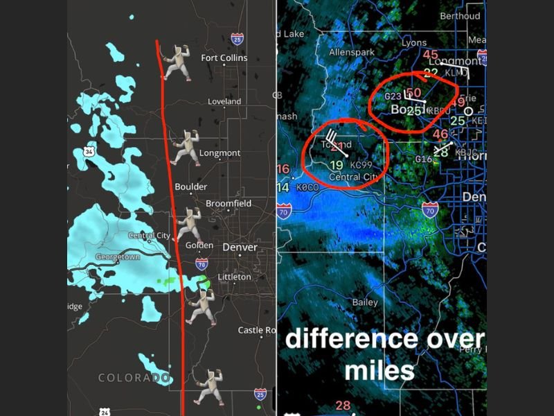
Radar imagery showed snow across higher terrain near Central City and Georgetown, but precipitation quickly weakened or disappeared as it moved east toward Boulder, Longmont, and Denver.
A 30-Degree Temperature Difference in 18 Miles
Surface observations revealed a dramatic contrast between the mountains and lower elevations. In Central City, temperatures hovered near 19 degrees with snow falling. Just 18 miles away in Boulder, readings were near 50 degrees.
That’s nearly a 30-degree temperature difference over less than 20 miles — enough to completely shut down snowfall as it moves downhill.
What Is Downslope?
Downsloping occurs when strong west to northwest winds descend off the mountains into lower elevations. As air descends, it compresses. When air compresses, it warms. And when it warms, it dries out.
That warming and drying effect essentially “eats away” at precipitation trying to move from higher elevations into cities along the Front Range.
This explains why snowfall can be steady in the foothills while Denver and surrounding suburbs remain dry or even sunny.
Elevation Matters: 7,000 to 9,000 Feet Sweet Spot
The most reliable corridor for snow in this setup is between 7,000 and 9,000 feet in elevation. Communities such as:
- Bailey
- Evergreen
- Conifer
- Nederland
- Estes Park
sit high enough to avoid the worst of the downslope warming and often continue seeing snow while lower elevations dry out.
Meanwhile, locations closer to I-25 — including Denver, Golden, and Boulder — can experience much warmer, drier air despite being only a short drive away.
Why It Didn’t Snow Earlier This Week
Earlier in the week, conditions were simply too warm and too dry for snowfall, even in the foothills. A cold front eventually helped lower temperatures aloft and raise humidity levels, allowing snow to develop at higher elevations.
But without deeper cold air in place at lower elevations, the downslope effect quickly shut it down east of the foothills.
Why This Matters
This type of setup is common along Colorado’s Front Range, where terrain plays a major role in day-to-day weather outcomes. Even small changes in wind direction or temperature profiles can dramatically alter where snow accumulates.
For now, snow remains mainly confined to higher elevations west of the I-25 corridor, while cities below the foothills continue to feel the warming and drying influence of descending mountain air.
Stay with NapervilleLocal.com for continued regional weather breakdowns and science-based explanations as conditions evolve.

I’ve lived in Naperville long enough to see how quickly our community changes — from new developments downtown to sudden shifts in our Midwest weather. Reporting on Naperville news and daily forecasts gives me the chance to keep neighbors informed about what really matters. My goal is simple: deliver clear, timely updates so you always know what’s happening in our city and what to expect from the skies above.