
Missouri, Kansas, and Oklahoma Face High Tornado Risk Friday as Forecasters Warn of EF2 Tornadoes, 3-Inch Hail, and 60+ MPH Winds
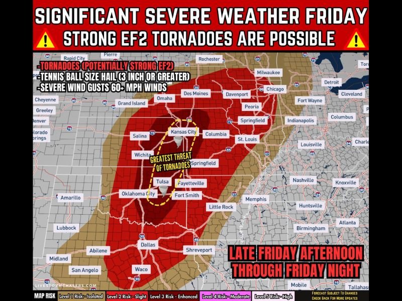
Missouri Valley — Meteorologists are warning that significant severe weather could erupt Friday afternoon through Friday night across parts of Kansas, Oklahoma, Missouri, and the central Plains, with the potential for strong EF2 tornadoes, giant hail up to three inches in diameter, and damaging winds exceeding 60 mph.
Forecast conditions appear highly favorable for supercell thunderstorms, a storm type known for producing the most intense tornadoes and large hail events. These storms are expected to form during the afternoon and continue intensifying into the evening hours as they track east across the region.
The developing storm system is being closely monitored because multiple severe hazards may occur simultaneously, making this a potentially dangerous weather setup for communities across the central United States.
Primary Severe Weather Threats Expected Friday
Weather analysts indicate that the storm environment Friday could support multiple forms of severe weather, particularly as thunderstorms strengthen into organized supercells.
The main threats include:
- Strong tornadoes (EF2 or stronger) capable of causing structural damage
- Very large hail ranging from 2 to 3 inches in diameter, roughly tennis-ball to baseball size
- Damaging wind gusts exceeding 60 mph, which could down trees and power lines
The combination of unstable warm air and strong atmospheric wind shear is expected to create conditions that allow storms to rotate, increasing the likelihood of tornado formation.
Forecasters note that supercell storms often produce the largest hail and strongest tornadoes, especially when they remain isolated before merging into larger storm systems.
Areas Facing the Greatest Tornado Risk
The highest concern zone currently stretches across eastern Kansas, much of Oklahoma, and western Missouri, where the atmospheric environment is expected to be most supportive of intense supercell development.
Communities located within this corridor may face the greatest potential for strong tornadoes and giant hail as storms move through during the late afternoon and evening.
Storms may also extend into surrounding regions of the central Plains and lower Missouri Valley, where severe wind gusts and large hail could remain possible even if tornado activity becomes less concentrated.
Meteorologists emphasize that localized storm intensity could vary significantly, meaning some areas may experience intense severe weather while others see only moderate storms.
Storm Development Timeline for Friday
Forecast models suggest a multi-stage severe weather event developing throughout the day Friday.
Late Friday Afternoon:
Thunderstorms are expected to begin developing across Kansas and Oklahoma, particularly along a corridor near the Interstate-35 region.
Friday Evening:
This period may bring the peak tornado and giant hail threat, as isolated supercells strengthen and rotate.
Friday Night:
As storms grow and merge, they may form a larger line of severe thunderstorms moving eastward, bringing widespread damaging winds and embedded tornado risks.
Forecasters say that storm organization overnight could allow severe weather to continue across the Missouri Valley region.
Why Meteorologists Are Closely Monitoring This System
Several atmospheric factors are expected to align Friday, creating a favorable setup for powerful thunderstorms.
Key ingredients include:
- Strong wind shear that encourages storm rotation
- A surge of warm, unstable air fueling thunderstorm growth
- A developing weather system moving across the Plains
When these ingredients combine, storms can quickly become intense supercells capable of producing large hail and strong tornadoes.
Meteorologists warn that Friday could become a significant severe weather day across parts of the central United States, and residents in the affected areas are encouraged to stay weather aware and monitor official forecasts as conditions develop.
For more regional weather updates and severe weather coverage, readers can continue following reports and safety information on NapervilleLocal.com.

Naperville is a community with stories that deserve to be told — both the serious ones about safety and justice, and the lighter ones that capture our culture and daily life. I focus on covering crime reports and court updates while also highlighting the traditions, events, and social trends that shape who we are. Through my reporting, I want to give readers a fuller picture of Naperville — the challenges we face and the character that keeps our city strong.