
Temperatures Plunge From Near 90 to the 30s and 40s Across North Carolina Mountains and Foothills After Cold Front Passage Sunday Morning
NORTH CAROLINA — A dramatic temperature crash is underway across the mountains and foothills of North Carolina this Sunday morning as a cold front sweeps through the region. As of 8:29 AM, temperatures have plummeted into the 30s and 40s across the higher elevations after sitting in the upper 80s to near 90 degrees for most areas just yesterday. The afternoon will bring a modest rebound into the 40s, 50s, and 60s, while Eastern North Carolina remains warmer but will see temperatures dropping as the front continues its eastward progress through the day.
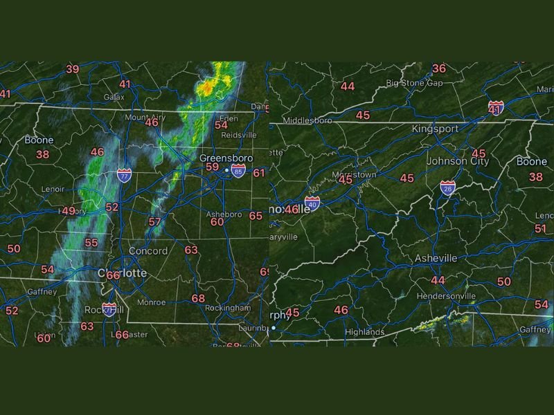
Dramatic Temperature Crash Hits Mountains and Foothills
The temperature contrast across North Carolina this morning is striking. Boone is sitting at just 38°F, with Asheville at 44°F and Hendersonville at 46°F. Meanwhile Charlotte is at 66°F, Greensboro at 59°F, and Rockingham at 66°F, illustrating the sharp temperature gradient between the cold post-frontal air in the mountains and the warmer air still in place further east and south.
The drop from near 90°F yesterday to the 30s and 40s this morning represents a temperature swing of 50 degrees or more in less than 24 hours across the highest elevations of western North Carolina.
Afternoon Rebound Into the 40s 50s and 60s Expected
Despite the cold morning readings, temperatures will rebound somewhat through the afternoon hours as daytime heating takes hold across the region. Mountain areas will climb back into the 40s, foothills communities will reach the 50s, and Piedmont areas will recover into the 60s by afternoon.
Eastern North Carolina will remain the warmest zone through the day, though temperatures there will also begin dropping noticeably as the cold front continues pushing eastward through the afternoon and evening hours.
Breezy Conditions With Passing Showers but Not Much Rain
Beyond the dramatic temperature drop, the cold frontal passage is bringing breezy conditions and a few passing showers across the region. However rainfall totals are expected to remain very light and not particularly impactful, with most areas seeing little to no meaningful precipitation despite the active frontal passage.
The combination of breezy winds and the sharp temperature drop will make conditions feel significantly colder than the thermometer readings suggest across the mountains and foothills through the morning and early afternoon hours. Stay with NapervilleLocal.com for the latest weather updates and local forecast coverage.

I’ve lived in Naperville long enough to see how quickly our community changes — from new developments downtown to sudden shifts in our Midwest weather. Reporting on Naperville news and daily forecasts gives me the chance to keep neighbors informed about what really matters. My goal is simple: deliver clear, timely updates so you always know what’s happening in our city and what to expect from the skies above.