
Indiana Severe Weather Alert: Strong Storms With Large Hail, Damaging Winds, and Possible EF-2 Tornadoes Target Northwest Indiana After 6 PM Tuesday
INDIANA — A round of potentially severe thunderstorms is expected to develop across much of Indiana Tuesday afternoon and evening, with northwest portions of the state facing the greatest risk for damaging weather as storms intensify after 6 PM Eastern Time.
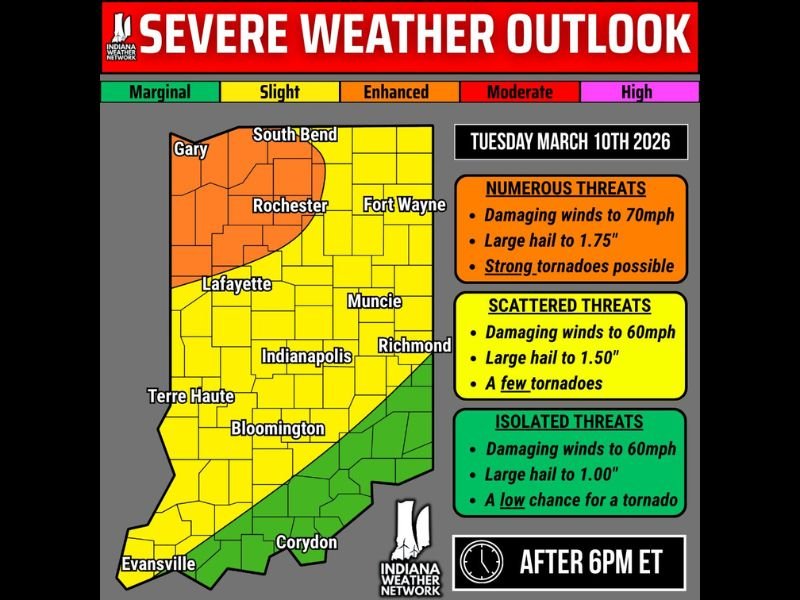
Meteorologists warn that numerous storms could form during the evening hours and continue through the overnight period into early Wednesday morning. The primary concerns include large hail, damaging winds, and the possibility of a few tornadoes, some of which could become strong in localized areas.
Northwest Indiana Faces the Highest Severe Weather Risk
Forecast outlooks show the highest severe storm risk concentrated across northwest Indiana, including areas near Gary, South Bend, and Rochester.
This region falls within the enhanced risk zone where the strongest storms are expected to develop. In these areas, forecasters say storms could produce:
- Damaging winds up to 70 mph
- Large hail up to around 1.75 inches in diameter
- A few strong tornadoes, potentially EF-2 or stronger
The combination of strong instability and favorable wind patterns could allow storms to become organized quickly once they develop Tuesday evening.
Widespread Storm Threat Across Central Indiana
Much of the rest of Indiana remains under a slightly lower but still significant storm risk. Cities including Indianapolis, Lafayette, Muncie, Richmond, Bloomington, and Terre Haute are expected to fall within a zone where scattered severe storms are possible.
In these areas, storm hazards may include:
- Damaging wind gusts up to 60 mph
- Large hail up to around 1.50 inches
- The potential for a few tornadoes
While storms may not be as intense as those farther northwest, severe weather could still develop quickly during the evening hours.
Southern Indiana Faces Lower But Not Zero Risk
Parts of southern Indiana, including areas near Corydon and Evansville, remain under a marginal risk level.
Storms that develop here could still produce isolated severe weather, including:
- Wind gusts up to 60 mph
- Large hail up to around 1 inch
- A low chance of a tornado
Even isolated storms in this region could briefly intensify, especially if they interact with stronger storm systems moving through the state.
Storm Timing Focused After 6 PM Tuesday
The most active weather period across Indiana is expected to begin around 6 PM Eastern Time Tuesday evening, when atmospheric conditions become more favorable for thunderstorm development. Storms may continue through the overnight hours into early Wednesday morning as they track across the state.
Because severe weather may develop quickly after sunset, forecasters encourage residents to ensure they have multiple ways to receive weather warnings, including mobile alerts or weather radios. As forecast models continue to refine the storm track and intensity, meteorologists will be closely monitoring developments leading up to Tuesday evening’s severe weather threat across Indiana.

I’ve lived in Naperville long enough to see how quickly our community changes — from new developments downtown to sudden shifts in our Midwest weather. Reporting on Naperville news and daily forecasts gives me the chance to keep neighbors informed about what really matters. My goal is simple: deliver clear, timely updates so you always know what’s happening in our city and what to expect from the skies above.