
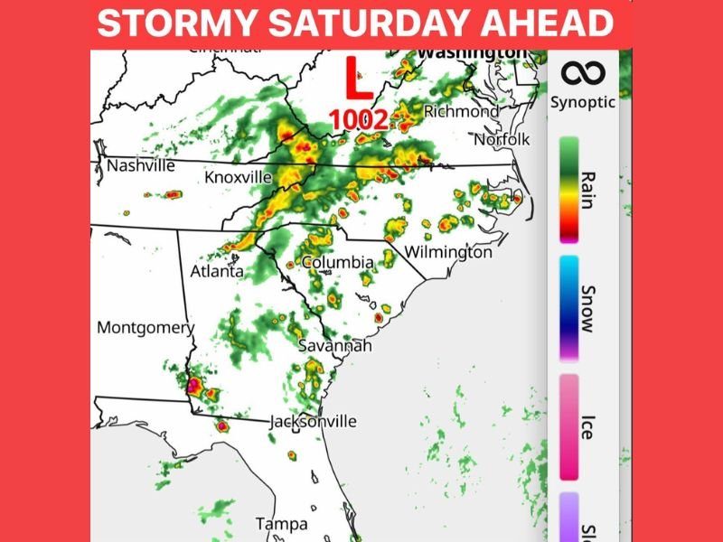
Scattered Heavy Rain, Thunder, and Lightning Moving Through Knoxville, Charlotte, and Southeast Coast Saturday With No Washout but Storms to Dodge Throughout the Day
SOUTHEAST AND CAROLINA COAST — A stormy Saturday is ahead across the Southeast and Carolina coastline as scattered and feisty storms push through the region with heavy rain, thunder, and frequent lightning at times. Radar shows an active storm band stretching from the Tennessee Valley through the Carolinas and down toward the Georgia and Florida coastlines, driven by a 1002 millibar low pressure system tracking through the region.
Scattered Feisty Storms Rather Than a Continuous Rain Event
The key characteristic of Saturday’s weather pattern across the Southeast is its scattered and summertime-like nature rather than a solid wall of rain moving through. Storm coverage will be uneven and unpredictable, with some areas seeing heavy downpours with loud thunder and lightning while nearby communities remain completely dry during the same window.
Radar already shows a broken but active storm band with yellow and red cores indicating the heavier rainfall intensity concentrated across portions of western North Carolina, the Knoxville corridor, and extending southward through the Carolinas toward the Georgia coast.
Heavy Rain and Lightning Are the Primary Concerns
With no significant severe weather designation associated with Saturday’s storm activity, the primary concerns are heavy rainfall rates and frequent lightning rather than damaging winds or large hail. The storms are described as feisty, meaning they will be capable of producing brief but intense downpours that could lead to localized street flooding and poor visibility during the heaviest rain episodes.
Lightning will accompany the heavier cells across the entire corridor from Tennessee southward through the Carolinas and into the Georgia and Florida coastlines, adding an outdoor safety concern for anyone with plans near water or in open areas during the afternoon and evening.
Outdoor Plans Will Be Fine With Some Flexibility
Forecasters are reassuring residents that Saturday’s stormy pattern does not require cancelling outdoor plans entirely. The scattered nature of the coverage means that most events and activities will proceed without significant disruption, with the main adjustment being awareness of developing storms and the willingness to seek brief shelter when a heavier cell moves through the immediate area.
Residents across Knoxville, Charlotte, Columbia, Wilmington, Savannah, and Jacksonville should keep a weather app handy Saturday and be prepared to duck inside briefly if a storm develops nearby, but widespread severe weather is not a concern for the day. Stay with NapervilleLocal.com for the latest weather updates and local forecast coverage.

I’ve lived in Naperville long enough to see how quickly our community changes — from new developments downtown to sudden shifts in our Midwest weather. Reporting on Naperville news and daily forecasts gives me the chance to keep neighbors informed about what really matters. My goal is simple: deliver clear, timely updates so you always know what’s happening in our city and what to expect from the skies above.