
Illinois and Midwest Severe Weather Alert: Strong Tornadoes, Giant Hail and 60+ MPH Winds Possible Tuesday Afternoon Into Overnight
ILLINOIS — Meteorologists are warning of a significant severe weather threat across the Midwest Tuesday afternoon through the overnight hours, with storms capable of producing strong tornadoes, very large hail exceeding 2 inches, and damaging wind gusts over 60 mph.
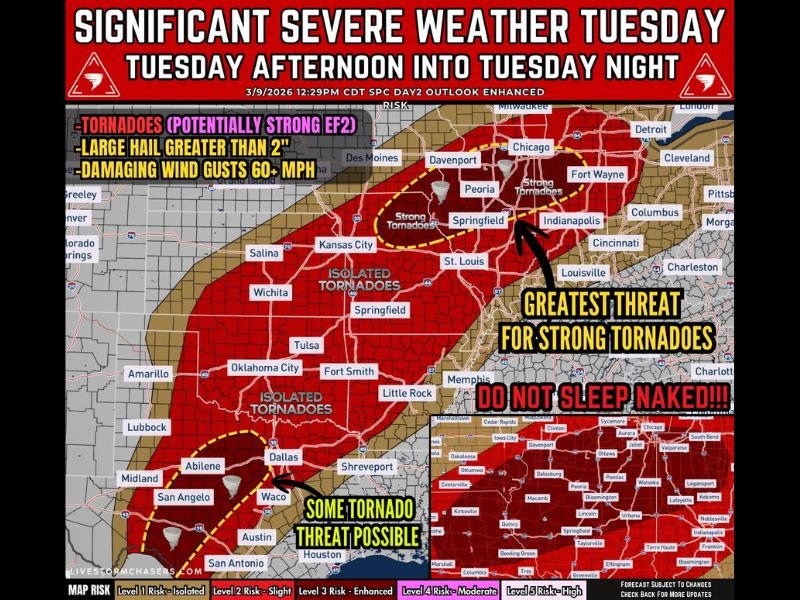
Forecast guidance suggests that a powerful storm system moving out of the Southern Plains toward the Great Lakes region will create conditions favorable for multiple severe hazards across several states. The greatest concern currently focuses on the warm-front corridor stretching from northern Missouri into central Illinois, where tornado potential appears highest.
Cities such as Springfield, Peoria, and areas west of Chicago toward the Quad Cities may fall within the region where the atmosphere becomes most supportive of severe thunderstorms.
Central Illinois Could See Highest Tornado Risk
Forecasters say the most concerning tornado potential may develop along a warm front expected to extend across central Illinois Tuesday afternoon and evening. Storms forming near this boundary could become discrete supercells, which are powerful rotating thunderstorms capable of producing tornadoes.
Meteorologists warn that some tornadoes could be strong, potentially reaching EF2 intensity, particularly if storms remain isolated long enough to strengthen before merging into larger storm clusters. The highest tornado potential is currently expected between approximately 3 PM and 8 PM CST, when atmospheric instability and wind shear will be most favorable.
Giant Hail Also a Major Concern
In addition to tornadoes, severe storms could produce very large hail exceeding 2 inches in diameter — roughly the size of golf balls or larger.
Large hail often forms in strong rotating thunderstorms, and forecasters say supercells developing along the warm front may be capable of producing significant hailstones capable of damaging vehicles, roofs, and crops. Communities across central Illinois and nearby parts of Missouri and Indiana may face this risk during the afternoon and evening hours.
Storms Could Transition Into Damaging Wind Event Overnight
As the evening progresses, individual storms may begin to merge into clusters or lines, increasing the potential for widespread damaging winds.
Once storms organize into lines, the primary threat often shifts toward strong straight-line wind gusts that could exceed 60 miles per hour. These winds can down trees, damage structures, and cause scattered power outages as storms move eastward through the Midwest overnight.
Second Severe Weather Zone Across Texas
While the Midwest may face the highest tornado risk, another corridor of severe weather is expected farther south across central Texas and the Southern Plains.
Storms may begin developing late Tuesday morning into early afternoon across north Texas toward the Texarkana region, where atmospheric conditions could allow supercells to form. These storms could produce very large hail around or exceeding 2 inches, along with the possibility of a few tornadoes. Later in the evening, storms may organize into larger clusters capable of producing damaging winds.
Residents Urged to Prepare Ahead of Tuesday Evening
Meteorologists emphasize that the developing setup is a bi-modal severe weather event, meaning multiple regions may experience significant storms during the same period.
Across the Midwest — particularly central Illinois and surrounding states — residents are encouraged to stay alert Tuesday afternoon and evening as storms begin developing. Because severe weather may continue into the overnight hours, forecasters recommend having multiple ways to receive weather alerts and ensuring a safety plan is in place should warnings be issued.

I’ve lived in Naperville long enough to see how quickly our community changes — from new developments downtown to sudden shifts in our Midwest weather. Reporting on Naperville news and daily forecasts gives me the chance to keep neighbors informed about what really matters. My goal is simple: deliver clear, timely updates so you always know what’s happening in our city and what to expect from the skies above.