
Georgia Severe Thunderstorm Warning: “Tornado Possible” Storm Moves Toward Atlanta With 60 MPH Winds Along I-85 Corridor
GEORGIA — A severe thunderstorm warning with a “tornado possible” tag has moved into parts of metro Atlanta, prompting meteorologists to closely monitor a line of strong storms pushing through western Georgia.
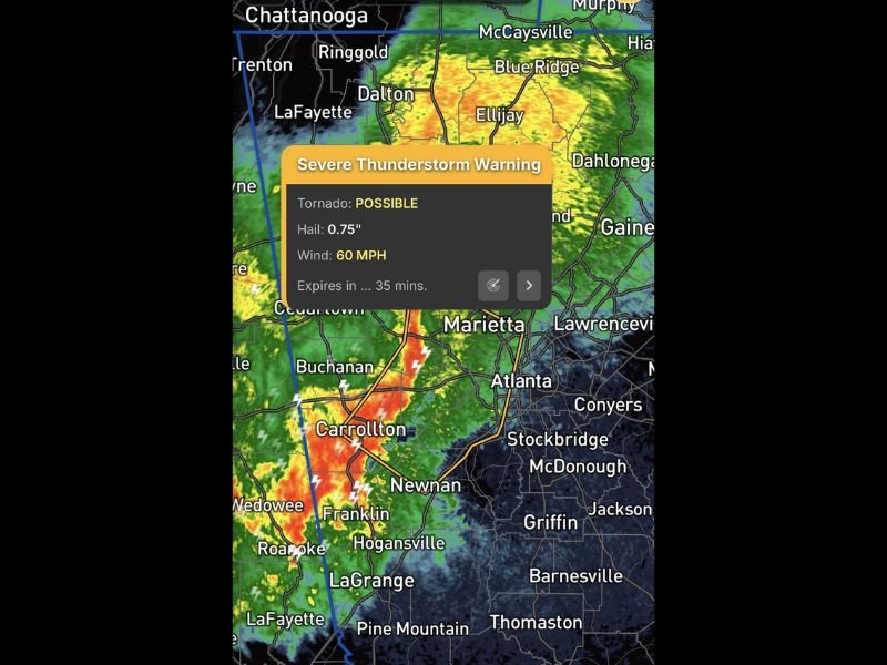
Radar imagery shows a powerful storm line stretching from areas near Carrollton and Buchanan through Franklin and Hogansville, with storms advancing toward the Atlanta metropolitan area. Forecasters say the system is capable of producing wind gusts up to 60 mph and hail around three-quarters of an inch, with the possibility of a brief tornado embedded within the storms. The warning highlights an area where storms are intensifying as they track eastward across the region.
Strong Storms Tracking Toward Metro Atlanta
Weather radar indicates the strongest storms are moving along and south of the Interstate 85 corridor, an important transportation route that runs through several cities across western and central Georgia.
Communities currently near the most intense storm activity include:
- Carrollton
- Buchanan
- Franklin
- Hogansville
- Areas near Newnan
As the storms continue eastward, the line could move closer to parts of Marietta and Atlanta, although meteorologists say the strongest severe weather may remain slightly south of the city center.
Tornado Possible Tag Triggers Close Monitoring
While the storm has not been confirmed to be producing a tornado, the “tornado possible” tag indicates radar signatures suggest conditions that could support rotation within the storm.
These types of warnings are issued when severe thunderstorms show characteristics that could allow a tornado to briefly form, especially within fast-moving storm lines. Meteorologists say storms embedded within the line could produce short-lived spin-ups, which can occur quickly and with little warning.
Severe Weather Focused South of I-85
Current analysis suggests that the most intense storms are tracking along and south of the I-85 corridor, which may limit the highest severe threat to southern portions of the Atlanta metro area.
However, heavy rainfall, lightning, and gusty winds may still impact areas closer to Marietta, Lawrenceville, Conyers, and surrounding suburbs as the storm complex moves eastward. Forecasters are continuing to monitor radar trends closely as the system evolves.
Storms May Weaken as They Move Northeast
Meteorologists say there are indications that the storms may gradually weaken as they move farther northeast, especially as they approach the Georgia–South Carolina Upstate region.
Even so, residents across the metro Atlanta region are encouraged to remain alert in case storms intensify again or produce damaging winds. Officials advise staying indoors during severe storms and keeping weather alerts enabled in case additional warnings are issued as the storm line continues moving through northern Georgia.

I’ve lived in Naperville long enough to see how quickly our community changes — from new developments downtown to sudden shifts in our Midwest weather. Reporting on Naperville news and daily forecasts gives me the chance to keep neighbors informed about what really matters. My goal is simple: deliver clear, timely updates so you always know what’s happening in our city and what to expect from the skies above.