
Carolinas and Mid Atlantic Face Dangerous Monday Severe Weather Outbreak With EF2 Tornado Threat and 70 MPH Winds
CHARLOTTE, NORTH CAROLINA — A potentially dangerous severe weather outbreak is expected Monday across the Carolinas and parts of the Mid-Atlantic, with forecasters warning that strong tornadoes, damaging winds and rapidly intensifying storms could impact communities from South Carolina through North Carolina and into Virginia and Maryland.
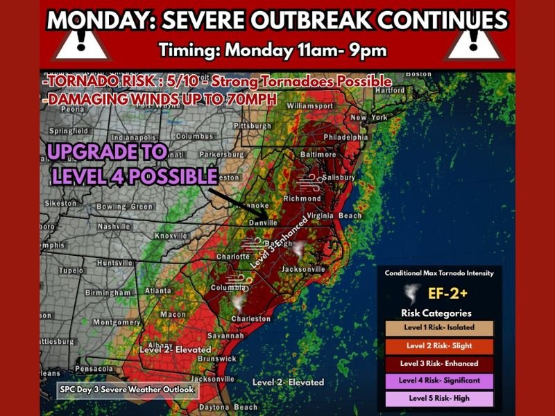
Meteorologists say the event could develop into a significant severe weather outbreak, with the greatest concern focused on the possibility of EF-2 or stronger tornadoes and widespread wind damage as storms move across the region. The main severe weather window is expected between 11 AM and 9 PM Monday, when atmospheric conditions may become favorable for powerful rotating storms.
Tornado Outbreak Risk Expands Across the Carolinas
Forecasters are closely monitoring a corridor stretching from South Carolina through North Carolina and north into Virginia and Maryland, where the potential for tornado development may increase as storms intensify.
Weather models suggest that pre-frontal storms developing ahead of the main squall line could create the greatest tornado risk. These storms often have the ability to rotate more strongly than storms embedded within the main line.
Cities including Columbia, Charleston and Savannah in South Carolina, as well as Charlotte and Raleigh in North Carolina, could experience dangerous thunderstorms capable of producing tornadoes during the afternoon hours.
Storm Prediction Center Monitoring Possible Level 4 Risk Upgrade
Forecasters indicate the event may be strong enough to warrant a Level 4 Moderate Risk, a classification used when significant severe weather is possible. This category signals an environment capable of producing multiple severe storms, including tornadoes and damaging wind events.
Areas from North Carolina through Virginia and toward Maryland, including cities such as Richmond, Norfolk, Baltimore and Salisbury, may fall within the zone where severe weather risks increase as the system moves north.
Meteorologists emphasize that while not every community will experience severe weather, the atmosphere appears capable of supporting a high-impact event across parts of the region.
Damaging Winds Could Reach 70 Miles Per Hour
In addition to tornadoes, forecasters warn that straight-line winds up to 70 mph could occur as storms organize into a powerful squall line moving through the region.
These winds have the potential to:
- Down trees and power lines
- Cause scattered power outages
- Damage roofs and structures
- Create hazardous travel conditions
The strongest winds are expected as storms rapidly intensify during the afternoon and evening hours.
Severe Weather Could Continue Into the Mid Atlantic
As the storm system tracks north and east, severe weather may continue impacting Virginia and parts of Maryland, including areas near Richmond, Virginia Beach, and Baltimore. Heavy rain, lightning and rapidly changing weather conditions may accompany the storms as they push across the region.
Meteorologists stress that Monday’s event has high potential for rapidly evolving weather, meaning conditions could change quickly as storms develop. Residents across the Carolinas and the Mid-Atlantic are encouraged to monitor weather alerts and have multiple ways to receive warnings should severe weather develop.
Stay with NapervilleLocal.com for continuing updates on this developing severe weather outbreak and additional national forecasts as meteorologists track the evolving storm threat.

I’ve lived in Naperville long enough to see how quickly our community changes — from new developments downtown to sudden shifts in our Midwest weather. Reporting on Naperville news and daily forecasts gives me the chance to keep neighbors informed about what really matters. My goal is simple: deliver clear, timely updates so you always know what’s happening in our city and what to expect from the skies above.