
Texas, Oklahoma, Louisiana, Arkansas, Mississippi, Alabama, Tennessee Face Growing Supercell Storm Threat as Late March Pattern Shift Signals Severe Outbreak
OKLAHOMA, TEXAS — A significant late-season atmospheric shift is setting the stage for a potentially active severe weather outbreak across the southern Plains, with forecast models highlighting a strong supercell risk from March 31 through April 6.
Meteorologists are pointing to a developing west-to-east trough-ridge pattern across North America that will allow Gulf moisture to surge northward. This setup is widely recognized as a classic trigger for severe thunderstorms, particularly across Texas, Oklahoma, Louisiana, Arkansas, Mississippi, and Alabama.
Strong Model Signals Point to Supercell Development
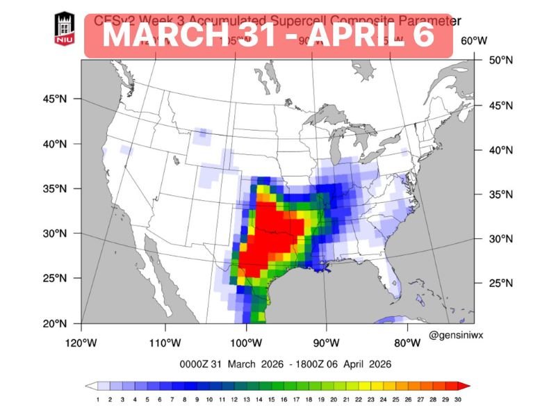
Forecast ensemble data shows a concentrated zone of high supercell potential centered over north-central Texas and much of Oklahoma, extending into western Louisiana and southern Arkansas.
The most intense risk zone — highlighted in red on forecast maps — suggests conditions highly favorable for organized severe storms, including supercells capable of producing large hail, damaging winds, and tornadoes.
Surrounding regions, including Mississippi, Alabama, and parts of Tennessee, are expected to see a lower but still notable severe weather risk as storms track eastward.
Gulf Moisture and Jet Stream Alignment Driving Threat
This upcoming pattern shift is being driven by a strengthening connection between Gulf moisture and upper-level dynamics. As warm, humid air flows north from the Gulf of Mexico, it will collide with cooler air masses and increasing wind shear aloft.
This combination creates the perfect environment for rotating thunderstorms — the hallmark of supercell development.
Meteorologists note that this setup resembles early spring severe weather patterns often seen during peak tornado season in the southern Plains.
Timing Window: March 31 Through April 6
The primary window for this developing threat spans from March 31 to April 6, with multiple rounds of storms possible rather than a single-day event.
This means impacted states — including Texas, Oklahoma, Louisiana, Arkansas, Mississippi, and Alabama — could face repeated storm systems, increasing the risk of cumulative impacts such as flash flooding and prolonged severe weather conditions.
Areas to Watch Closely
The highest concern currently focuses on:
- Central and North Texas
- Oklahoma statewide
- Western Louisiana
- Southern Arkansas
Meanwhile, downstream impacts may extend into:
- Mississippi and Alabama
- Western Tennessee
Residents across these regions are advised to begin monitoring forecasts closely as details become clearer in the coming days.
What This Means Moving Into Early April
This pattern shift signals the potential start of a more active severe weather period heading into April. With strong model agreement already in place, confidence is increasing that the southern Plains could see a notable outbreak scenario.
While exact storm timing and intensity will be refined closer to the event, the current data strongly suggests that this will not be a routine spring system.
Final Outlook
As the March-to-April transition approaches, all eyes remain on the southern Plains and lower Mississippi Valley. Meteorologists continue to monitor evolving conditions, with updates expected as the event window nears.
Residents across Texas, Oklahoma, Louisiana, Arkansas, Mississippi, and Alabama should stay weather-aware and prepared for potential severe weather alerts in the days ahead.

I’ve lived in Naperville long enough to see how quickly our community changes — from new developments downtown to sudden shifts in our Midwest weather. Reporting on Naperville news and daily forecasts gives me the chance to keep neighbors informed about what really matters. My goal is simple: deliver clear, timely updates so you always know what’s happening in our city and what to expect from the skies above.