
Storms Firing This Afternoon Transitioning to Overnight Rain and Thunder Across the Carolinas and Mid-Atlantic With Higher Rain Chances Continuing Friday and Saturday
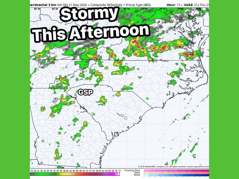
CAROLINAS AND MID-ATLANTIC — A stormy afternoon and evening is shaping up across the Carolinas and Mid-Atlantic region on Thursday, May 21, 2026, as scattered storms begin popping up through the afternoon hours before transitioning into overnight rain and thunder. Experimental 3km composite reflectivity valid at 21z Thursday shows widespread storm development stretching from the Appalachians eastward through the coastal zones, with the Greenville-Spartanburg corridor and surrounding areas well within the active threat zone. Rain chances climb even higher heading into Friday and Saturday as the pattern remains persistently unsettled across the region.
Scattered Storms Popping Up This Afternoon Across the Carolinas and Appalachian Corridor
Radar simulations initialized at 06z May 21 show storms beginning to fire across the broader Carolinas region through the afternoon hours, with activity developing from the Appalachian foothills eastward. The Greenville-Spartanburg area sits within the active corridor as storm cells begin organizing during the peak afternoon heating period.
Strong storm cores are depicted across portions of Tennessee and into the western Carolinas, with additional development pushing toward the piedmont and coastal plain zones. Anyone with outdoor afternoon plans across the region should have a backup shelter option ready as conditions deteriorate through the day.
Storm Activity Transitions to Overnight Rain and Thunder Through the Evening Hours
As the afternoon storm rounds progress, activity is expected to transition into a more widespread overnight rain and thunder pattern across the Carolinas and Mid-Atlantic zones. The radar simulation shows a continuous and organized band of precipitation stretching across Virginia, Maryland, and into the coastal Mid-Atlantic corridor through the evening valid period.
This overnight transition means storm and rain impacts will not be limited to daytime hours Thursday. Residents should expect unsettled and potentially disruptive weather conditions continuing well through the overnight period before any meaningful break arrives.
Higher Rain Chances Return Friday and Saturday Keeping the Region on Alert
Friday and Saturday bring even higher rain chances across the Carolinas and Mid-Atlantic, extending the unsettled pattern well beyond Thursday’s initial storm round. The persistent active weather setup means back-to-back days of elevated storm and rainfall potential for communities already dealing with Thursday’s activity.
Staying connected to local forecast updates through the end of the week is strongly recommended for all residents across the region. Outdoor plans for the upcoming weekend should include a weather contingency given the elevated and continuing rain threat through Saturday. Stay with NapervilleLocal.com for the latest weather updates and local forecast coverage.

I’ve lived in Naperville long enough to see how quickly our community changes — from new developments downtown to sudden shifts in our Midwest weather. Reporting on Naperville news and daily forecasts gives me the chance to keep neighbors informed about what really matters. My goal is simple: deliver clear, timely updates so you always know what’s happening in our city and what to expect from the skies above.