
North Carolina Sees Chilly Midweek Weather as Raleigh, Charlotte, Greensboro Stay in 40s While Coastal Areas Near 50 Degrees
NORTH CAROLINA — A chilly start to the day is setting the tone across the state, with temperatures struggling to climb as most areas remain locked in the 40s, marking a below-average midweek pattern.
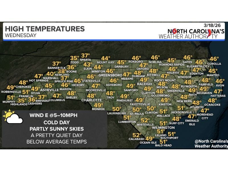
Forecasters say the state will see partly sunny skies with increased cloud cover compared to previous days, keeping temperatures cooler than typical for this time of year.
Widespread 40s Across Major Cities
Temperature readings across North Carolina show a consistent pattern of cool conditions stretching from the mountains to the coast.
Cities including Raleigh, Charlotte, Greensboro, Durham, and Winston-Salem are all expected to top out between 46 and 49 degrees, reflecting a statewide trend of suppressed daytime warming.
Even typically warmer inland areas such as Fayetteville, Goldsboro, and Wilson are hovering close to the upper 40s, reinforcing the overall cool air mass in place.
Slightly Warmer Along the Coast
Coastal communities are seeing marginally higher temperatures, with locations like Wilmington, Jacksonville, and Southport reaching into the low 50s.
Areas such as Emerald Isle, Atlantic Beach, and the Outer Banks including Hatteras and Corolla are also expected to remain in the upper 40s to near 50 degrees.
Despite this slight coastal warmth, temperatures remain below seasonal averages statewide.
Mountain Regions Stay Coldest
Western North Carolina is experiencing the coldest conditions, particularly in higher elevations.
Locations such as Boone, Banner Elk, and Sparta are seeing highs in the mid to upper 30s, while nearby areas like Asheville and Hickory are only reaching the mid-40s.
This sharp contrast highlights the influence of elevation and lingering cold air across the Appalachian region.
Quiet Weather Pattern with Light Winds
Conditions across the state remain calm, with east winds between 5 to 10 mph and no significant storm activity expected.
The overall setup points to a quiet weather day, offering a break from any recent active patterns while maintaining cooler-than-normal temperatures.
Warming Trend Expected Into the Weekend
While Wednesday remains cool, forecasters indicate that temperatures will begin to rise gradually heading into the weekend.
This warming trend is expected to bring more spring-like conditions back to North Carolina, with milder afternoons and more comfortable outdoor weather.
Final Outlook
For now, North Carolina residents should prepare for a cool and calm midweek day, with temperatures largely staying in the 40s statewide and only limited warming along the coast.
The good news is that this chill won’t last long, as a steady warm-up is already on the horizon heading into the latter part of the week.

I’ve lived in Naperville long enough to see how quickly our community changes — from new developments downtown to sudden shifts in our Midwest weather. Reporting on Naperville news and daily forecasts gives me the chance to keep neighbors informed about what really matters. My goal is simple: deliver clear, timely updates so you always know what’s happening in our city and what to expect from the skies above.