
Ohio Pennsylvania West Virginia Kentucky Indiana Severe Storm Risk Sunday Brings Damaging Winds Large Hail and Isolated Tornado Threat Along I 70 Corridor
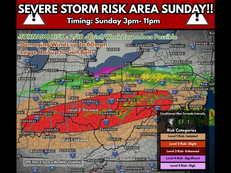
OHIO VALLEY — A developing severe weather setup is expected to impact multiple states across the Ohio Valley and Central Appalachians on Sunday, with forecasters highlighting a Level 2 (Slight Risk) for damaging storms capable of producing strong winds, large hail, and isolated tornadoes.
The threat will develop during the late afternoon and continue through the evening hours, roughly between 3 PM and 11 PM, as a cold front moves through the region.
Storm Threat Expands From Indiana to Pennsylvania
The primary risk zone stretches from Indiana and Kentucky through Ohio, West Virginia, and into Pennsylvania, covering major cities such as Indianapolis, Cincinnati, Columbus, Cleveland, Pittsburgh, and surrounding areas.
This corridor, especially along and near the I-70 corridor, is expected to see the most organized storm activity as conditions become favorable for severe thunderstorm development.
Damaging Winds and Large Hail Expected as Main Hazards
Forecasters emphasize that the primary threats will be damaging straight-line winds and large hail, with wind gusts potentially reaching up to 60 mph.
Hail could grow to the size of golf balls, particularly in stronger storms that develop during peak heating hours.
These hazards could lead to:
- Downed trees and power lines
- Damage to vehicles and property
- Hazardous travel conditions during storms
Tornado Risk Remains Low but Not Zero
While the tornado threat is considered low, it is not completely absent.
Forecast guidance suggests a brief or weak tornado potential, especially if storms remain discrete before merging into a larger storm complex later in the evening.
The tornado risk is highly dependent on storm structure and how long individual cells can remain isolated.
Storm Evolution Could Shift Impacts
Storms are expected to initially form as discrete supercells, which carry a higher risk for hail and isolated tornadoes.
As the evening progresses, these storms may merge into a larger line or complex, increasing the risk for widespread damaging winds.
This transition will play a key role in determining which areas see the most intense impacts.
Timing and Travel Concerns
The 3 PM to 11 PM window will be critical for storm development and movement across the region.
Commuters and travelers should be especially cautious during late afternoon and evening hours, as storms could develop quickly and intensify along major highways, including I-70 and surrounding routes.
What Residents Should Prepare For
Residents across Indiana, Kentucky, Ohio, West Virginia, and Pennsylvania should stay alert for rapidly changing weather conditions Sunday afternoon and evening.
Preparation steps include:
- Monitoring weather alerts and warnings
- Securing outdoor objects ahead of strong winds
- Having a safe place identified in case severe storms develop
Even though this is not a high-end outbreak, the combination of wind, hail, and isolated tornado potential makes this a notable severe weather event across the Ohio Valley. Forecasters will continue to refine details as Sunday approaches, and residents are encouraged to stay updated on the latest information.

I’ve lived in Naperville long enough to see how quickly our community changes — from new developments downtown to sudden shifts in our Midwest weather. Reporting on Naperville news and daily forecasts gives me the chance to keep neighbors informed about what really matters. My goal is simple: deliver clear, timely updates so you always know what’s happening in our city and what to expect from the skies above.