
Damaging Winds Large Hail and Tornado Threat Targeting Upper Peninsula and Western Lower Michigan With Severe Risk Extending Into Tuesday May 18
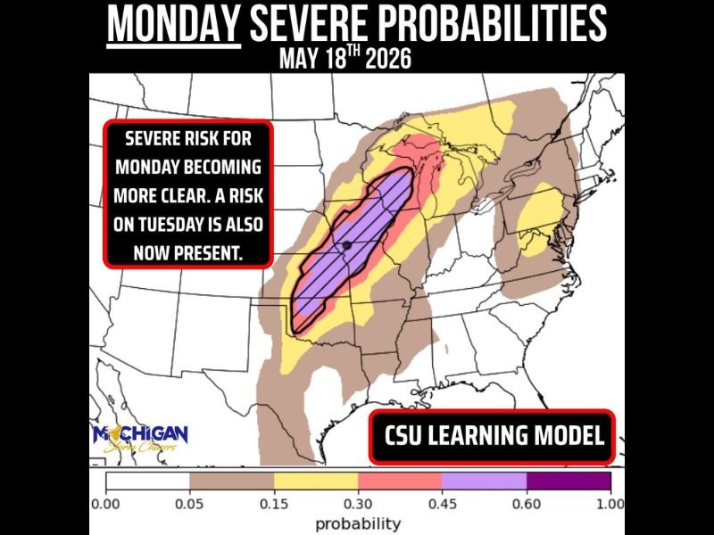
MICHIGAN — Monday’s severe weather picture is coming into sharper focus for Michigan, with the upper peninsula and portions of western lower Michigan carrying the best chance for significant severe weather during the late afternoon and evening hours on May 18, 2026. Damaging winds and large hail are the primary concerns, while any tornado risk will depend heavily on capping and storm mode as the event unfolds. A severe weather risk on Tuesday is now also confirmed, extending the dangerous stretch beyond Monday across the region.
Upper Peninsula and Western Lower Michigan Face Highest Severe Risk Late Afternoon Into Evening
The CSU learning model is keying in on the upper peninsula as the highest probability zone for severe weather Monday, with western lower Michigan following closely behind. The threat window is best during the late afternoon into the evening timeframe, giving residents daylight hours to prepare before conditions deteriorate.
Much of the more significant severe weather is expected to stay focused across Wisconsin and back into the plains, keeping the Michigan threat more concentrated along the upper and western corridors.
Damaging Winds and Large Hail Lead the Hazard List With Tornado Risk Conditional
Damaging winds and large hail are the two primary hazards forecasters are most confident about heading into Monday across the Michigan risk zone. Any tornado potential will rely heavily on whether the cap breaks favorably and what storm mode develops as systems push into the region during the evening hours.
Final details on storm mode and tornado potential will become clearer over the next 24 hours as the event draws closer and forecast confidence increases.
Tuesday Severe Risk Now Confirmed Adding Another Dangerous Day for the Region
Beyond Monday, a severe weather risk on Tuesday is now officially present across the region, extending what is shaping up to be a multi-day significant weather event for Michigan and surrounding areas. Tuesday’s specific details and probabilities will be assessed at 4 PM today as forecasters get a better handle on the evolving pattern.
Residents across the upper peninsula and western lower Michigan should prepare for back-to-back days of severe weather potential and keep weather alerts active through Tuesday evening. Stay with NapervilleLocal.com for the latest weather updates and local forecast coverage.

I’ve lived in Naperville long enough to see how quickly our community changes — from new developments downtown to sudden shifts in our Midwest weather. Reporting on Naperville news and daily forecasts gives me the chance to keep neighbors informed about what really matters. My goal is simple: deliver clear, timely updates so you always know what’s happening in our city and what to expect from the skies above.