
Michigan, Wisconsin, Minnesota Winter Pattern Returns With 20s and 30s, Light Snow Showers and Gusty Winds Across Great Lakes
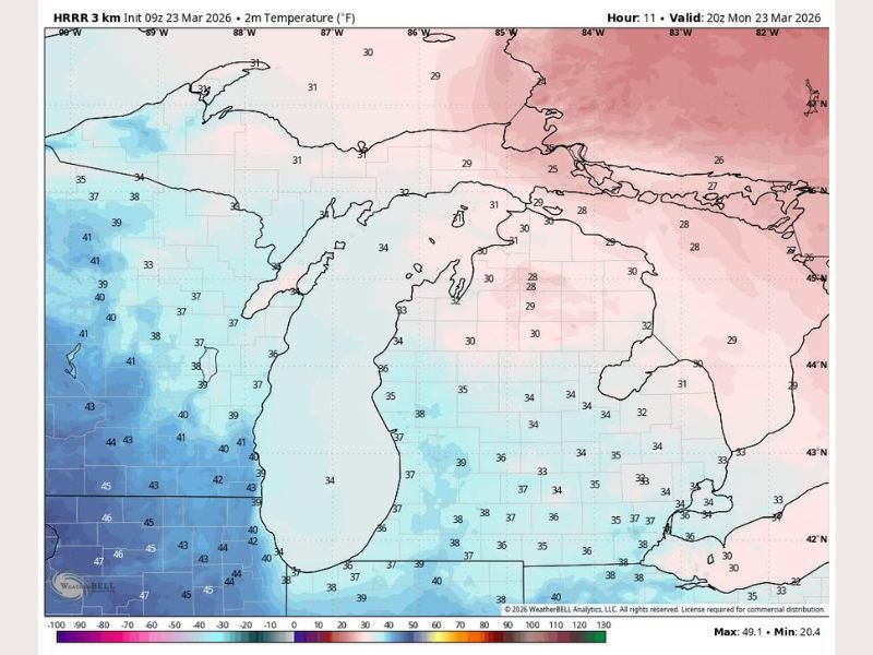
GREAT LAKES REGION — A late-season blast of winter is settling back across parts of the Upper Midwest and Great Lakes, with temperatures stuck in the 20s and 30s across Michigan, Wisconsin, and Minnesota today, bringing a stark reminder that spring is still struggling to take hold.
Forecast data shows a widespread chill across the region, with no major storm system, but enough cold air and instability to keep conditions unsettled.
Cold Temperatures Dominate Across Multiple States
Temperatures across the region are running well below recent trends:
- Northern Michigan and Upper Peninsula: Upper 20s to low 30s
- Lower Michigan: Low to mid 30s
- Wisconsin: Mid 30s to low 40s in some western areas
- Minnesota: Upper 30s to low 40s, slightly milder to the west
This creates a noticeable gradient, with the coldest air centered over Michigan and gradually moderating westward.
Spotty Snow Showers Through the Day
While this is not a major winter storm, light snow showers are expected to develop intermittently throughout the day, especially in:
- Northern Michigan
- Upper Peninsula
- Parts of Wisconsin
Accumulations are expected to remain minimal, but brief bursts of snow could reduce visibility at times.
Gusty Winds Add to the Winter Feel
Winds will also play a role in making it feel colder:
- Gusts reaching up to 20 mph
- Wind chills dropping below actual temperatures
- Blustery conditions persisting through much of the day
These winds, combined with cloud cover, will reinforce the winter-like atmosphere.
Gradual Clearing Later Today
Conditions are expected to improve slightly by late afternoon:
- Skies transition from mostly cloudy to partly cloudy
- Snow showers begin to taper off
- Temperatures remain cool but stabilize
This gradual clearing will offer some relief after a gray and chilly start.
A Reminder That Winter Isn’t Done Yet
Even as the calendar moves deeper into spring, this pattern highlights how quickly conditions can shift in the Great Lakes region.
The combination of:
- Cold air lingering over the region
- Weak disturbances triggering snow showers
- Gusty winds enhancing the chill
…creates a day that feels much more like mid-winter than late March.
What Residents Should Expect
- Bundle up for a cold and breezy day
- Watch for brief snow showers, especially north
- Expect improving skies later, but temperatures remain below average
For now, winter is making one more appearance across the Great Lakes. Stay tuned to NapervilleLocal.com for ongoing updates on shifting weather patterns across Illinois and the broader Midwest.

I’ve lived in Naperville long enough to see how quickly our community changes — from new developments downtown to sudden shifts in our Midwest weather. Reporting on Naperville news and daily forecasts gives me the chance to keep neighbors informed about what really matters. My goal is simple: deliver clear, timely updates so you always know what’s happening in our city and what to expect from the skies above.