
Missouri, Illinois, Indiana, Ohio Under Day 4 Severe Storm Risk Thursday as Models Signal Wind Shear and Spring Instability
MISSOURI, ILLINOIS, INDIANA, OHIO — A developing Day 4 severe weather outlook for Thursday, March 26 is raising concerns across parts of the Midwest, where early signals point to a corridor of storm potential stretching from northeast Missouri through Illinois, Indiana, and into Ohio.
While still several days out, forecasters say the ingredients for severe weather are beginning to come together, making this a setup worth watching closely.
Storm Corridor Taking Shape Across the Midwest
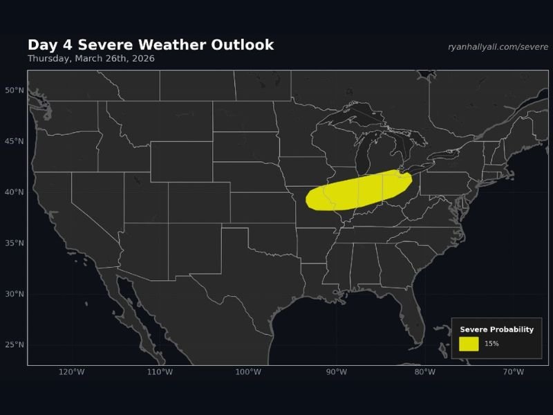
Forecast guidance highlights a 15% severe weather probability zone, which is significant for a Day 4 outlook.
The risk area currently includes:
- Northeast Missouri
- Central and eastern Illinois
- Much of Indiana
- Western and central Ohio
This region aligns with a developing boundary where warm, moist air will collide with an approaching system, creating favorable conditions for thunderstorms.
Key Ingredients Beginning to Align
Meteorologists are focusing on two major factors driving this potential setup:
- Rising dewpoints into the 60s – signaling increasing moisture in the atmosphere
- Strong wind shear – allowing storms to organize and potentially become severe
This combination is often associated with springtime severe weather events, especially when storms can tap into both instability and wind energy. Although exact storm timing and coverage are still uncertain, the environment may support organized thunderstorms by Thursday afternoon or evening.
What Types of Severe Weather Are Possible?
If storms develop as projected, the primary threats could include:
- Damaging wind gusts capable of downing trees or power lines
- Large hail, especially with stronger storm cores
- A low but not zero tornado risk, depending on storm structure and timing
At this stage, forecasters emphasize that details will evolve, but the overall pattern supports at least some level of severe weather potential.
Why This Outlook Matters Now
A Day 4 outlook with a defined risk area means confidence is increasing in a potentially active setup, even if specifics are still being refined.
This early signal gives communities across the Midwest time to:
- Stay aware of forecast updates
- Review severe weather safety plans
- Monitor changes in storm timing and intensity
What to Watch Over the Next Few Days
Key forecast trends to monitor include:
- How far north moisture returns into the Midwest
- The strength and timing of the approaching system
- Whether storms remain isolated (more severe potential) or form into a line
Even small shifts in these factors can significantly impact the severity and location of storms.
Bottom Line
While it’s still early, Thursday’s setup across Missouri, Illinois, Indiana, and Ohio is showing classic signs of a spring severe weather event.
Residents across the region should stay alert for forecast updates as confidence increases and details become clearer in the coming days. Stay with NapervilleLocal.com for the latest on this developing severe weather threat.

I’ve lived in Naperville long enough to see how quickly our community changes — from new developments downtown to sudden shifts in our Midwest weather. Reporting on Naperville news and daily forecasts gives me the chance to keep neighbors informed about what really matters. My goal is simple: deliver clear, timely updates so you always know what’s happening in our city and what to expect from the skies above.