
Oklahoma, Texas, Kansas, Arkansas, Missouri Face Rising Severe Storm Threat Near April 1 With Tornado Risk Hail and Damaging Winds Possible
TULSA, OKLAHOMA — A developing weather pattern across the Southern Plains and mid-Mississippi Valley is raising concerns for a potential round of strong to severe storms near April 1, with Oklahoma and surrounding areas emerging as a key region to watch.
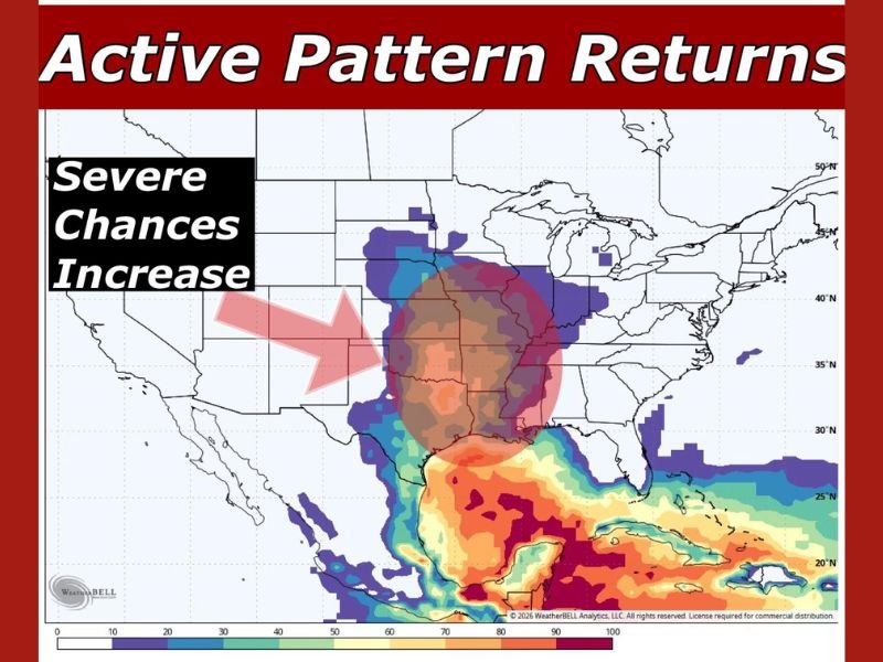
Forecast signals indicate increasing instability across the region, with the highest concentration of severe weather potential centered near northeastern Oklahoma, including the Tulsa area.
Active Pattern Begins to Strengthen Across Region
The overall weather pattern is beginning to shift into a more active phase, with conditions becoming favorable for storm development across the Southern Plains.
Model guidance shows a growing area of severe weather probabilities expanding across Oklahoma and nearby states, suggesting a setup that could support organized thunderstorms.
Multiple Severe Weather Hazards Possible
As the system develops, several hazards are already being highlighted as potential risks. These include strong to severe thunderstorms capable of producing damaging wind gusts and large hail.
A tornado threat is also part of the early outlook, although it will need closer monitoring as the event gets nearer. Heavy rainfall is another concern, with the potential for widespread precipitation across parts of the region.
Tulsa and Surrounding Areas in Focus
The highest probability zone in the current outlook is positioned over Oklahoma, placing Tulsa and surrounding communities near the center of the developing system. This positioning increases the likelihood that storms forming in the region could become more organized and potentially severe.
Timing Still Several Days Away
While the signal for severe weather is becoming more consistent, the event is still about a week out. This means exact timing, storm intensity, and specific locations could still change as new data becomes available. However, the consistency in forecast models suggests this is a situation worth monitoring closely.
Preparedness Recommended Ahead of Potential Storms
With the possibility of severe weather increasing, residents across Oklahoma and the Southern Plains are encouraged to begin early preparations.
Ensuring weather alerts are enabled, identifying a safe shelter location, and staying connected to trusted updates will be important steps in the days leading up to the potential event.
What Happens Next
Forecast updates are expected to refine the outlook over the coming days, providing clearer details on storm timing and severity. For now, the developing pattern signals a potential return of active and possibly severe weather across Oklahoma and surrounding states as April begins.
Stay with NapervilleLocal.com for continued updates as this potential severe weather event approaches and more details become available.

I’ve lived in Naperville long enough to see how quickly our community changes — from new developments downtown to sudden shifts in our Midwest weather. Reporting on Naperville news and daily forecasts gives me the chance to keep neighbors informed about what really matters. My goal is simple: deliver clear, timely updates so you always know what’s happening in our city and what to expect from the skies above.