
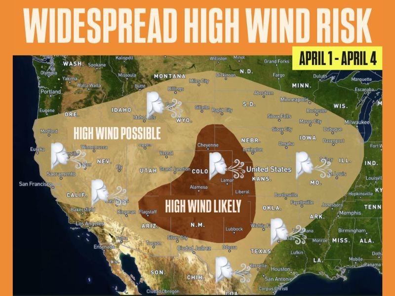
Colorado, New Mexico, Kansas, Texas, Wyoming and Plains Face Widespread High Wind Risk April 1 Through April 4 With Strong Gusts Possible Across West and Central US
UNITED STATES — A widespread high wind pattern is expected to develop across large portions of the West and Plains heading into the first week of April, with multiple states facing the potential for strong and possibly damaging wind gusts.
The setup is expected to take shape between April 1 and April 4, as a trough builds across the western United States while a ridge strengthens over the East, creating a favorable environment for strong winds.
Broad Wind Risk Spans West and Central United States
Forecast guidance highlights a large area of concern stretching from the western states into the central Plains. States including Colorado, New Mexico, Kansas, Texas, and Wyoming are positioned within a core zone where high winds are considered likely.
Surrounding regions, including parts of Utah, Arizona, Nebraska, and Missouri, may also experience elevated wind conditions during this period.
Strongest Winds Expected in Central High Plains
The highest concentration of wind risk is centered across parts of Colorado and New Mexico, extending into western Kansas and nearby areas.
This region is identified as the most likely area to experience stronger and more persistent wind gusts, potentially reaching advisory or warning levels.
Setup Driven by West Trough and East Ridge Pattern
The developing pattern features a trough across the western United States combined with a ridge across the eastern half of the country.
This contrast in atmospheric pressure systems can enhance wind speeds across the Plains, especially in areas between the two systems where pressure gradients tighten.
Advisory and Warning Level Winds Possible
The current outlook suggests that winds could reach levels that meet advisory or even warning criteria in some locations. While exact wind speeds are not specified, this type of setup is commonly associated with strong, sustained winds and higher gust potential.
Widespread Impacts Possible Across Multiple States
Given the size of the highlighted area, impacts could extend across a broad region, affecting travel, outdoor activities, and infrastructure.
Open areas across the Plains are particularly vulnerable to strong winds, which can lead to reduced visibility, difficult driving conditions, and potential damage to unsecured objects.
What Happens Next
As the event approaches, forecast details will become clearer, including the exact timing and intensity of winds across specific states. For now, the early signal points to a widespread and impactful wind event developing across the West and Plains during the first days of April.
Residents across Colorado, New Mexico, Kansas, Texas, Wyoming, and surrounding states should stay alert for updates as this high wind pattern evolves. Stay with NapervilleLocal.com for continued coverage and updates on this developing high wind threat across the United States.

I’ve lived in Naperville long enough to see how quickly our community changes — from new developments downtown to sudden shifts in our Midwest weather. Reporting on Naperville news and daily forecasts gives me the chance to keep neighbors informed about what really matters. My goal is simple: deliver clear, timely updates so you always know what’s happening in our city and what to expect from the skies above.