
Damaging Winds Over 60 MPH and Large Hail Targeting Western Ohio Including Dayton Springfield Troy and Greenville With Two Storm Waves Between 2 PM and 10 PM Saturday
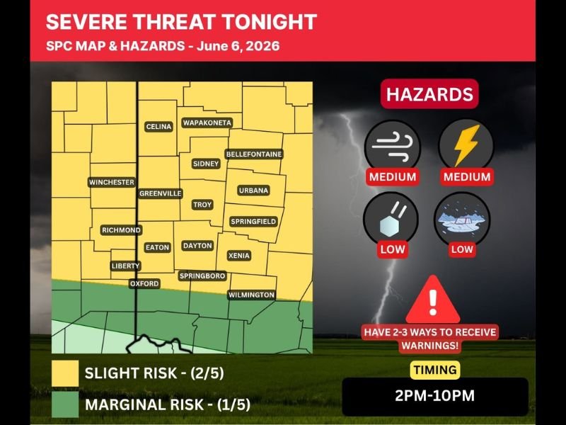
WESTERN OHIO — A Storm Tracking Alert is now in effect across western Ohio Saturday June 6th as the entire area moves into a Level 2 Slight Risk of severe weather, with two distinct waves of storms expected to impact the region between 2 PM and 10 PM. The SPC hazard map shows a yellow Slight Risk zone covering communities from Celina and Wapakoneta southward through Bellefontaine, Urbana, Springfield, Dayton, Troy, Xenia, and Wilmington.
Damaging winds in excess of 60 mph and hail over one inch in diameter are the primary threats, with medium confidence on both wind and lightning hazards across the risk zone.
First Wave Enters Now From Indiana Staying Mainly North of US-35
The first storm wave is moving into the area from Indiana during the late morning hours and is expected to remain sub-severe overall, tracking mainly north of US-35 with gusty winds and lightning as the primary non-severe hazards. This first batch will help set a boundary across the area that could serve as a focus point for new and potentially stronger storm development later in the afternoon.
A brief holding pattern between the two waves will allow forecasters to monitor how the atmosphere destabilizes ahead of the more significant second round.
Second and More Dangerous Wave Expected 2 PM Through 10 PM
The second and more impactful wave of storms is forecast to develop in Indiana and move southeast across western Ohio through the afternoon and evening hours with the primary severe weather window running from 2 PM through 10 PM. Damaging winds exceeding 60 mph and hail of one inch or larger are the headline threats within this second wave.
Repeated downpours from both waves could also lead to localized flooding concerns given the still-elevated deep soil moisture across the region.
Have Two to Three Ways to Receive Warnings Before 2 PM Today
Given the heightened outdoor activity levels on a Saturday afternoon, forecasters are strongly urging residents across the Slight Risk zone to have two to three active ways to receive severe weather warnings before the 2 PM storm window opens. Not every storm will be severe and some locations may receive little to no rain, but preparedness is essential across the full risk corridor today. Stay with NapervilleLocal.com for the latest weather updates and local forecast coverage.

I’ve lived in Naperville long enough to see how quickly our community changes — from new developments downtown to sudden shifts in our Midwest weather. Reporting on Naperville news and daily forecasts gives me the chance to keep neighbors informed about what really matters. My goal is simple: deliver clear, timely updates so you always know what’s happening in our city and what to expect from the skies above.