
Wind Gusts 60 to 70 MPH and Quarter-Sized Hail Targeting Pennsylvania Including Pittsburgh Harrisburg Allentown and State College Saturday Afternoon Into Evening
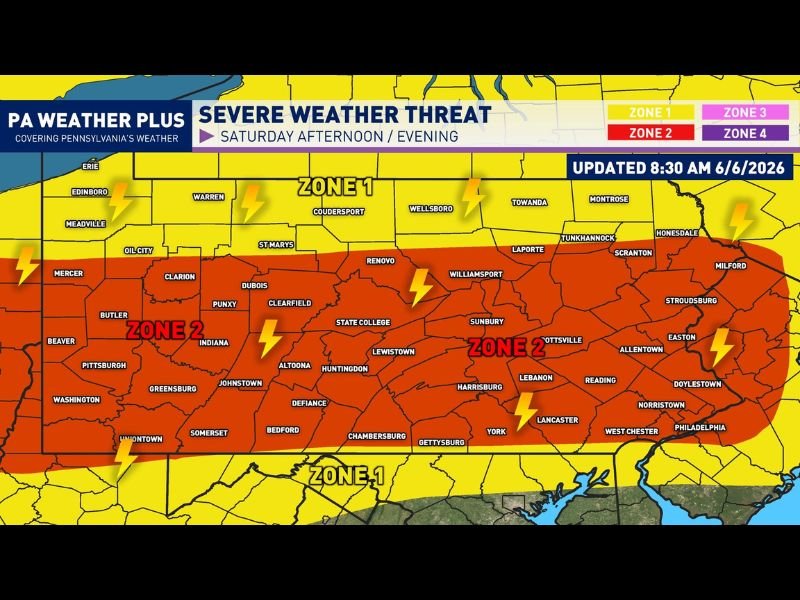
PENNSYLVANIA — An uptick in severe weather potential is underway across Pennsylvania Saturday afternoon and evening as a cold front pushes through the state, with a risk now covering the entire commonwealth from Pittsburgh eastward through Harrisburg, Allentown, State College, and the Philadelphia suburbs. The severe weather threat map updated at 8:30 AM June 6th shows Zone 2 red coverage blanketing central and western Pennsylvania with Zone 1 yellow surrounding the full state perimeter.
Ahead of the front, significant instability and wind shear are in place to support multiple storm clusters and damaging wind segments through the afternoon and evening hours.
Zone 2 Red Coverage Brings 60 to 70 MPH Gusts and Quarter-Sized Hail
The Zone 2 red designation covering Pittsburgh, State College, Harrisburg, Allentown, Reading, Lancaster, and surrounding communities carries the highest severe weather risk Saturday. Scattered strong to severe thunderstorms are expected across this zone, with the strongest storms capable of packing wind gusts of 60 to 70 mph and hail up to quarter-size.
Torrential downpours and frequent lightning are additional non-severe hazards expected across Zone 2 regardless of whether individual storms reach severe criteria.
Zone 1 Yellow Covers Northern Pennsylvania With 55 to 65 MPH Wind Gusts
The Zone 1 yellow zone across northern Pennsylvania including Erie, Meadville, Warren, Wellsboro, and Scranton carries an isolated strong to severe thunderstorm threat with wind gusts of 55 to 65 mph possible in the strongest cells. Tornado potential is very unlikely across both zones, keeping the focus squarely on wind and hail as the primary severe hazards Saturday.
Torrential downpours and lightning will affect both zones even outside of any formally severe storm activity.
Have Multiple Ways to Receive Alerts and Know Your Shelter Location
Forecasters are emphasizing that severe weather does not impact every neighborhood equally, and residents across both Zone 1 and Zone 2 should have multiple ways to receive severe weather alerts active before storms arrive. A longer-lived damaging wind segment is being monitored but confidence remains uncertain at this time.
Know your shelter location before the afternoon storm window opens across Pennsylvania. Stay with NapervilleLocal.com for the latest weather updates and local forecast coverage.

I’ve lived in Naperville long enough to see how quickly our community changes — from new developments downtown to sudden shifts in our Midwest weather. Reporting on Naperville news and daily forecasts gives me the chance to keep neighbors informed about what really matters. My goal is simple: deliver clear, timely updates so you always know what’s happening in our city and what to expect from the skies above.