
Michigan Severe Weather Outlook Explains Risk Levels 0 Through 6 as Southern Michigan Faces Thursday Storm Potential
SOUTHERN MICHIGAN — As a potential round of severe weather approaches parts of southern Michigan on Thursday, a newly released outlook is helping residents better understand what different risk levels actually mean.
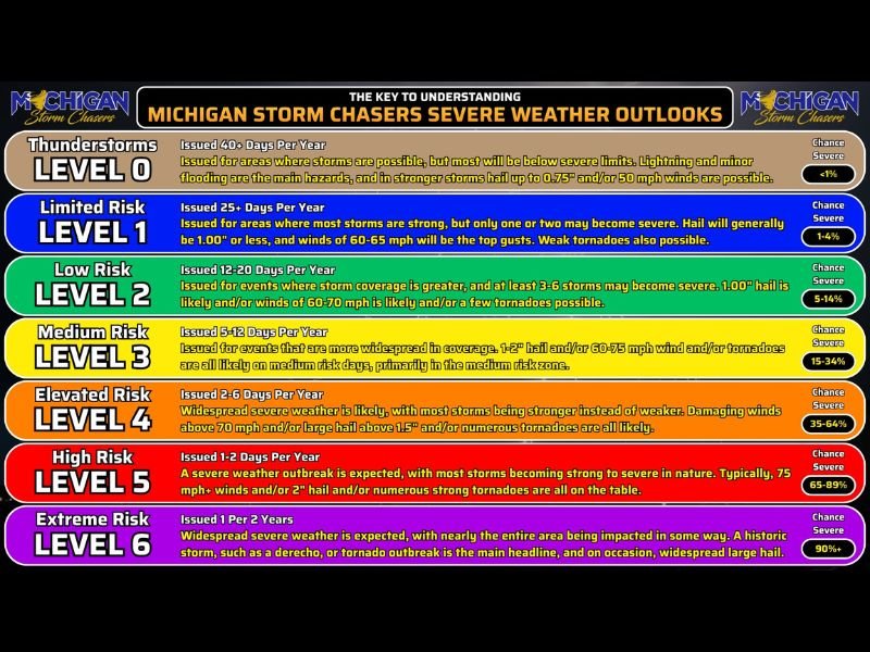
The in-house severe weather outlook highlights how storms are categorized, ranging from general thunderstorms to rare, high-end outbreak scenarios, offering a clearer picture of what to expect when risk levels increase.
Understanding the Severe Weather Risk Scale
The outlook breaks down severe weather into levels ranging from 0 to 6, each representing increasing intensity and coverage of storms.
Level 0 refers to general thunderstorms where severe weather is not expected, though lightning and minor impacts may still occur. Level 1 introduces a limited risk, where a few storms could become severe, bringing hazards such as small hail and gusty winds.
Increasing Risk Brings Stronger Storm Potential
At Level 2, storms become more widespread, with several capable of turning severe. This includes the potential for larger hail and stronger winds. Level 3 represents a medium risk, where more organized and widespread severe storms are possible, including the chance for tornado development.
Higher Levels Signal More Widespread and Dangerous Conditions
Level 4 indicates elevated risk, where severe weather becomes more widespread, and stronger storms dominate the event. This level may include damaging winds exceeding 70 mph, large hail over 1.5 inches, and an increased tornado threat.
Level 5 signals a high risk, typically associated with significant severe weather outbreaks, including numerous strong storms and potentially dangerous conditions across a large area.
Rare Extreme Events at Highest Level
Level 6 represents the most extreme category, which is rarely issued and typically reserved for major, widespread severe weather events.
These could include large-scale outbreaks with damaging winds, significant tornado activity, or widespread impacts across an entire region.
Why This Matters Ahead of Thursday
With a developing severe weather setup expected Thursday across southern Michigan, understanding these categories can help residents better interpret forecasts and prepare accordingly.
Even lower-level risks can still produce isolated severe weather, while higher levels indicate a more widespread and impactful event.
What Residents Should Do
Residents are encouraged to stay informed as updated forecasts are released, especially as Thursday’s storm potential becomes clearer. Knowing the difference between risk levels can help determine how serious a developing weather situation may become.
Stay with NapervilleLocal.com for continued updates and detailed breakdowns of severe weather risks across Michigan and surrounding regions.

I’ve lived in Naperville long enough to see how quickly our community changes — from new developments downtown to sudden shifts in our Midwest weather. Reporting on Naperville news and daily forecasts gives me the chance to keep neighbors informed about what really matters. My goal is simple: deliver clear, timely updates so you always know what’s happening in our city and what to expect from the skies above.