
Ohio Cities Including Toledo, Defiance, Lima, Dayton and Columbus Under Enhanced Risk Thursday With Damaging Winds Large Hail and Storm Line Possible
TOLEDO, OHIO — A potentially significant severe weather setup is taking shape across Ohio for Thursday, with parts of the state now placed under an enhanced risk — signaling a higher likelihood of impactful storms capable of producing damaging conditions. The setup is drawing attention due to a combination of strong atmospheric ingredients that could support organized and potentially widespread severe weather.
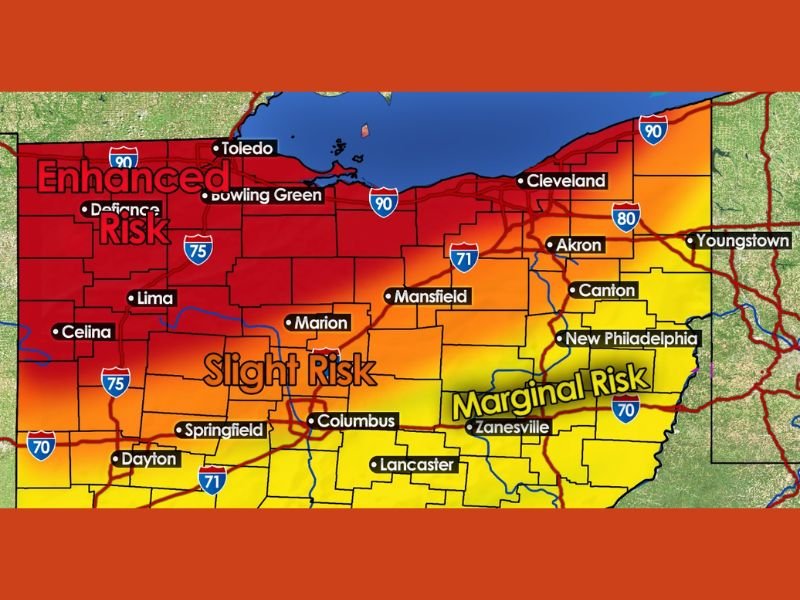
The greatest concern currently centers across northwest Ohio, but the risk extends across much of the state, meaning millions of residents could be affected as conditions evolve through the day.
Enhanced Risk Highlights Northwest Ohio
Northwest Ohio has been identified as the core area of concern, including cities such as Toledo, Defiance, Bowling Green, and Lima. This enhanced risk level indicates that storms in this region have a stronger potential to become organized and produce more intense impacts compared to lower-risk areas.
In setups like this, storms are more likely to sustain themselves for longer periods, increasing the chances of widespread wind damage or repeated storm activity across the same locations.
Slight and Marginal Risks Extend Across the State
Moving southeast, a broader slight risk zone stretches across central Ohio, including Columbus, Marion, Springfield, and nearby communities. In this zone, storms may not be as intense as in the enhanced area, but still have the potential to become severe and produce hazardous weather.
Further east, areas such as Zanesville, Canton, Akron, and Youngstown are under a marginal risk. While the threat is lower, isolated severe storms are still possible, especially if conditions locally become more favorable during the day.
Warm Air Surge Sets the Stage for Storm Development
During the daytime hours Thursday, a surge of warm air is expected to push temperatures close to or above 70 degrees across much of Ohio. This warming plays a key role in building instability in the atmosphere.
As this warm, moisture-rich air mass strengthens, it creates the fuel storms need to grow taller and more powerful. This unstable environment sets the stage for rapid storm development once a triggering mechanism arrives.
Cold Front Expected to Trigger Storm Line
Later in the day, an approaching cold front is expected to move into the region, acting as the primary trigger for storm development. When this front collides with the warm, unstable air already in place, it can force storms to rapidly form and intensify.
This type of setup often leads to the development of a more organized line of storms, sometimes referred to as an MCS, which can travel long distances while producing consistent impacts along its path.
Damaging Winds and Large Hail Main Concerns
The primary threats with this system are expected to be damaging wind gusts and large hail. Wind speeds could exceed 70 mph in stronger storms, which is enough to cause tree damage, power outages, and structural impacts.
Hail could also become a significant concern, with some storms capable of producing hail up to golf ball size. These conditions can pose risks to vehicles, roofs, and outdoor property. Additionally, embedded rotation within the storm line is possible, meaning that while tornadoes are not the main threat, isolated spin-ups cannot be ruled out entirely.
Timing Focused on Late Afternoon Into Evening
Current projections suggest that storms are most likely to develop during the late afternoon and continue into the evening hours. This timing is important, as it coincides with a period when many people are commuting or finishing daily activities.
However, the exact timing and intensity will depend on how quickly the atmosphere destabilizes and how the cold front interacts with the environment.
What Residents Should Expect
Residents across Ohio should be prepared for rapidly changing weather conditions Thursday, especially in areas under enhanced and slight risk zones. Storms could develop quickly and become severe within a short period of time.
Having multiple ways to receive weather alerts, securing loose outdoor items, and staying aware of forecast updates will be important as the situation develops.
What Happens Next
Forecast updates over the next 12 to 24 hours will refine the risk areas and provide a clearer picture of storm timing and severity. There is also the possibility that risk levels could be adjusted depending on how conditions evolve.
For now, the setup signals a potentially active and impactful severe weather day across Ohio, particularly in the northwest and central parts of the state. Stay with NapervilleLocal.com for continued updates as this enhanced risk severe weather event develops.

I’ve lived in Naperville long enough to see how quickly our community changes — from new developments downtown to sudden shifts in our Midwest weather. Reporting on Naperville news and daily forecasts gives me the chance to keep neighbors informed about what really matters. My goal is simple: deliver clear, timely updates so you always know what’s happening in our city and what to expect from the skies above.