
Michigan Temperature Split on March 25 Brings 30s Near Sault Ste. Marie, 60s Across Southern Cities and Gusty Winds Ahead of Thursday Storm Threat
MICHIGAN — Michigan is set for another day of split weather conditions on Wednesday, but this time with warmer temperatures spreading across more of the state. While snow showers and colder air continue to brush northern areas, much of the Lower Peninsula will see a milder day with highs climbing into the 50s and 60s, creating a dramatic contrast from one end of the state to the other.
The overall setup closely resembles Tuesday in terms of the north-south divide, but Wednesday’s forecast pushes the warmer air farther across the state. That means many communities, especially in southern Michigan, will get a noticeably more spring-like feel, while northern locations remain stuck in a cooler and cloudier pattern.
Southern Michigan Warms Up While the North Stays Much Cooler
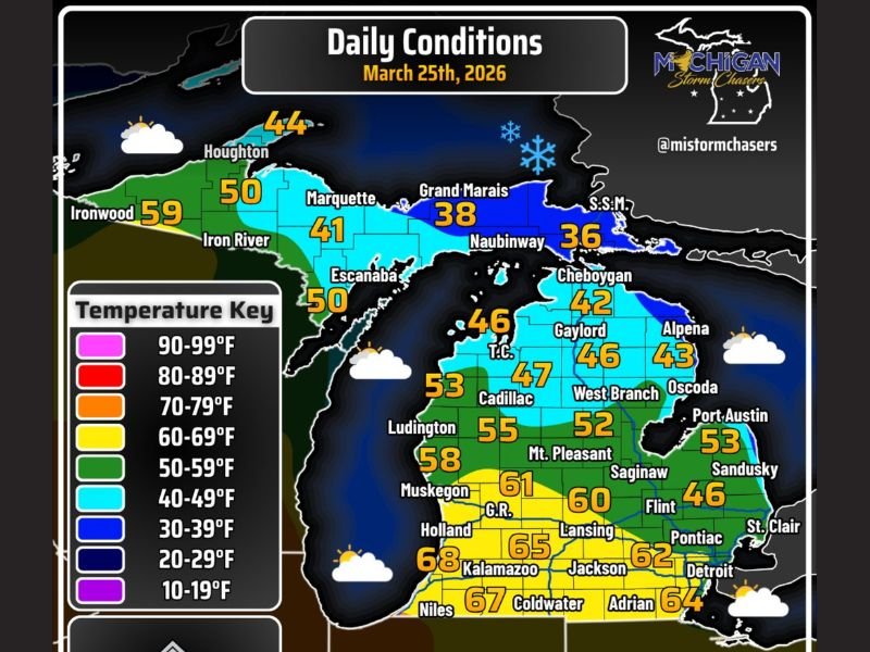
The strongest warmth is expected across southern Michigan, where highs are projected to rise well into the 60s. Areas near Kalamazoo, Niles, Coldwater, Jackson, Adrian, and Detroit are forecast to top out in the mid to upper 60s, with the warmest spot near New Buffalo in Berrien County approaching 69 degrees. Grand Rapids is expected to reach around 61, while Lansing sits near 60.
That warmth stands in sharp contrast to the eastern Upper Peninsula and parts of northern Lower Michigan, where temperatures remain much lower. Sault Ste. Marie is forecast to be the cold spot of the day at just 34 degrees, while Grand Marais stays near 38 and nearby northern communities remain mostly in the 30s and 40s. This creates a striking temperature swing of roughly 35 degrees from north to south across the state.
Northern Areas See Clouds and Light Snow Showers
While southern Michigan enjoys milder air and at least some breaks in the clouds, northern parts of the state will deal with a less pleasant setup. Mostly cloudy skies are expected across the Upper Peninsula and northern Lower Michigan, and some isolated snow showers may pass through the far north during the day.
The good news is that any snowfall is expected to stay light and brief, with no indication of a major accumulation event. Even so, the presence of snow showers this late in March highlights just how sharply divided Michigan’s weather pattern remains, with spring-like warmth in one part of the state and lingering winter-like conditions in another.
Winds Add Another Layer to Wednesday’s Forecast
In addition to the temperature contrast, gusty winds will also be part of Wednesday’s weather story. Winds are expected to gust between 15 and 25 mph across much of the Lower Peninsula, which could make conditions feel a bit cooler than the actual air temperature at times, especially in exposed areas.
Along the Lake Michigan shoreline, a few gusts could reach as high as 35 mph. That may not be enough for major impacts inland, but it is strong enough to create rougher marine conditions and draw attention from boaters and small craft interests. Even in warmer areas, the wind will keep the day from feeling completely calm or settled.
Forecast Map Shows a State Divided by Air Masses
The temperature map makes the divide easy to see. Southern Michigan is firmly in the 60s zone, central areas sit mostly in the 50s, northern Lower Michigan ranges through the 40s, and the eastern Upper Peninsula drops into the 30s. Communities such as Muskegon, Ludington, Saginaw, and Mount Pleasant fall into the middle ground, showing how the warmer air gradually fades moving north.
That kind of setup is important because it often signals a stronger boundary nearby, and boundaries like that can become more meaningful when the weather pattern turns more active. Wednesday may not bring major severe weather by itself, but it helps set the stage for what could happen next.
Attention Already Turning to Thursday
Even as Michigan moves through Wednesday’s conditions, attention is already shifting to Thursday. The forecast mentions the possibility of an even larger temperature gradient developing, along with the chance for late afternoon severe weather in southern Michigan.
That means Wednesday serves as a transition day — mild and quiet for many, but also a preview of a more dynamic setup that could follow. If warmer air continues pushing north and interacts with stronger weather ingredients on Thursday, southern Michigan could face a more active and potentially more impactful forecast.
What Michigan Residents Should Expect
For Wednesday, the main takeaway is that much of Michigan will see a warmer day than Tuesday, especially in the southern half of the state. Still, residents in the north should not expect the same spring feel, as colder air, clouds, and isolated snow showers remain in place there.
With gusty winds, a 35-degree statewide temperature spread, and increasing attention on Thursday’s weather, Michigan’s forecast remains far from uniform. Residents should enjoy the milder conditions where they arrive, but also keep an eye on the next round of forecast updates as the pattern continues to evolve.
Stay with NapervilleLocal.com for more detailed weather coverage, state-by-state forecast updates, and developing storm outlooks across the Midwest.

I’ve lived in Naperville long enough to see how quickly our community changes — from new developments downtown to sudden shifts in our Midwest weather. Reporting on Naperville news and daily forecasts gives me the chance to keep neighbors informed about what really matters. My goal is simple: deliver clear, timely updates so you always know what’s happening in our city and what to expect from the skies above.