
Illinois Wisconsin Weather Whiplash Sees 70 Degree Warmth Turn Into Severe Storm Risk Then Overnight Crash to 20s With Wind Chills in Teens
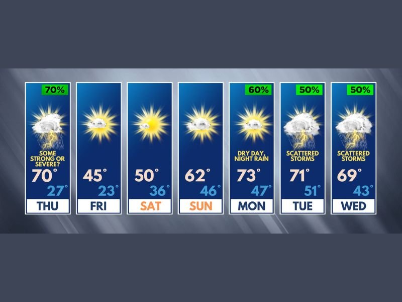
NORTHERN ILLINOIS — A dramatic weather swing is unfolding across Illinois and southern Wisconsin, with springlike warmth quickly giving way to a sharp temperature drop and storm potential. After reaching the 70s, conditions are expected to plunge into the 20s overnight, marking one of the most abrupt changes of the month.
Spring Warmth Peaks Before Sudden Crash
Thursday continues an unusual stretch of warm days, with temperatures climbing into the 70s once again across the region. This marks multiple instances of above-average warmth during March, reinforcing a pattern of early spring-like conditions.
However, this warmth will be short-lived. A strong system is expected to push through by evening, triggering both storms and a rapid drop in temperatures.
Storm Threat Builds Thursday Afternoon and Evening
Along with the temperature shift, there is a risk for strong to locally severe storms developing during the afternoon into early evening hours. The primary concerns include gusty winds and the possibility of hail.
These storms could impact parts of northern Illinois and southern Wisconsin before colder air quickly moves in behind the system.
Temperatures Plunge Overnight With Wind Chills in the Teens
Following the storms, temperatures are expected to fall sharply, dropping from the 70s during the day into the 20s overnight. Wind chills could dip even further, potentially reaching into the teens.
This rapid change will create a stark contrast in conditions within just a matter of hours, catching many off guard after the earlier warmth.
Calmer and Cooler Conditions Heading Into the Weekend
After Thursday’s active weather, conditions begin to stabilize. Friday will bring cooler temperatures, with highs in the mid-45s and colder morning lows.
Saturday and Sunday look more comfortable, with temperatures gradually rebounding into the 50s and low 60s under calmer skies, offering a brief break from the volatility.
Warmer and More Active Pattern Returns Next Week
The pattern shifts again heading into next week, with temperatures climbing back into the upper 60s and low 70s. However, this warmth will come with increased chances of rain and thunderstorms.
Showers and storms are expected to develop starting Monday night and continue intermittently through midweek, signaling a more active spring pattern taking hold across Illinois and Wisconsin.
What Residents Should Expect
Residents across northern Illinois and southern Wisconsin should prepare for rapidly changing conditions, especially on Thursday. From warm temperatures and storm risks to a sharp overnight freeze, this system will bring multiple impacts in a short time frame.
Stay with NapervilleLocal.com for the latest updates, local forecasts, and real-time alerts as this volatile weather pattern continues to evolve.

I’ve lived in Naperville long enough to see how quickly our community changes — from new developments downtown to sudden shifts in our Midwest weather. Reporting on Naperville news and daily forecasts gives me the chance to keep neighbors informed about what really matters. My goal is simple: deliver clear, timely updates so you always know what’s happening in our city and what to expect from the skies above.