
Illinois, Iowa, Missouri, Indiana, Kansas, Nebraska Multi Day Severe Weather Threat Builds From Chicago to Kansas City Through Late Week Stretch
DES MOINES, IOWA — A broad and potentially impactful severe weather pattern is setting up across the Midwest, with multiple states including Iowa, Illinois, Missouri, Indiana, Kansas, and Nebraska facing an extended stretch of storm chances from Wednesday through Sunday.
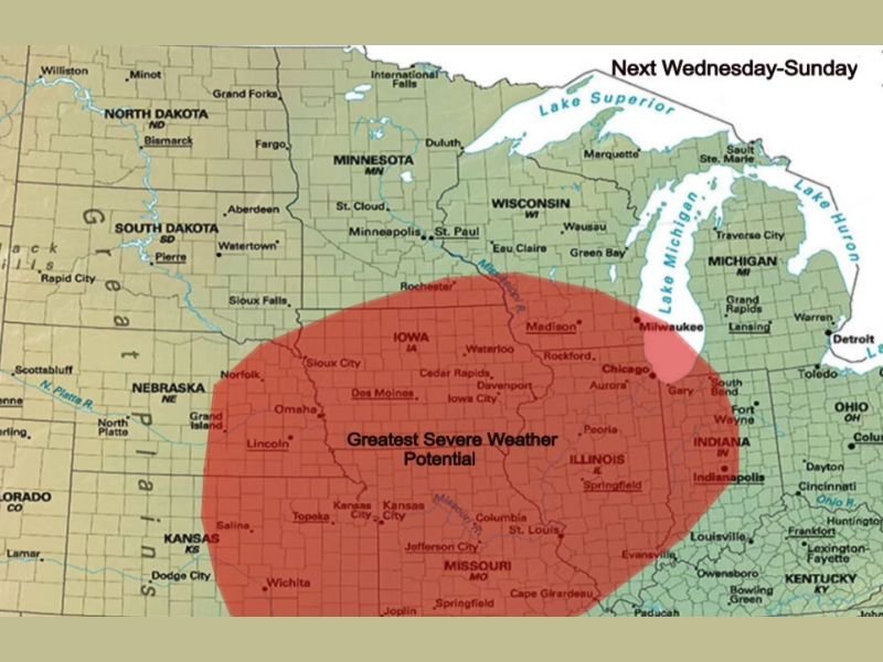
Large Severe Weather Zone Centered Across Iowa and Illinois
Forecast data highlights a wide corridor of greatest severe weather potential stretching from central Kansas and Nebraska through Missouri and Iowa into Illinois and Indiana. Cities such as Kansas City, Des Moines, Cedar Rapids, Davenport, Chicago, and Indianapolis fall within this core zone. This setup suggests repeated opportunities for storm development across the same areas over several days.
Chicago and Surrounding Areas Included in Risk Zone
Northern Illinois, including Chicago and nearby communities, sits within the eastern edge of the highlighted risk area. This places the region in line for potential storm impacts during multiple rounds throughout the period.
Areas extending into northern Indiana and southern Wisconsin may also see storm activity, though the highest concentration remains just to the southwest.
Multi Day Setup Raises Concern for Repeated Storms
Unlike a single storm event, this pattern indicates a prolonged period where conditions remain favorable for severe weather. That increases the risk of multiple rounds of storms affecting the same locations.
This type of setup can lead to cumulative impacts, especially if storms repeatedly track over similar areas.
Forecast Uncertainty Still Remains
Despite the strong signal for active weather, it remains too early to determine whether a concentrated outbreak of severe storms will occur. Small changes in timing, storm track, and atmospheric conditions could significantly alter the outcome. Forecasters emphasize that this is a developing situation that will require close monitoring as the week progresses.
Why This Pattern Matters
A large-scale weather pattern like this typically involves strong atmospheric dynamics that support storm development across a wide region. When combined with moisture and instability, it can create an environment favorable for severe thunderstorms. However, the exact placement of the most intense storms will depend on how individual systems evolve each day.
What Residents Should Expect
Residents across Iowa, Illinois, Missouri, Indiana, Kansas, and Nebraska should prepare for an active weather period from midweek into the weekend. While not every location will see severe conditions each day, the repeated chances increase the overall risk.
Staying informed and prepared for changing conditions will be important as the situation develops. Stay with NapervilleLocal.com for continuous updates, regional forecasts, and real-time alerts as this multi-day severe weather threat unfolds across the Midwest.

I’ve lived in Naperville long enough to see how quickly our community changes — from new developments downtown to sudden shifts in our Midwest weather. Reporting on Naperville news and daily forecasts gives me the chance to keep neighbors informed about what really matters. My goal is simple: deliver clear, timely updates so you always know what’s happening in our city and what to expect from the skies above.