
Pennsylvania Pittsburgh Severe Storms Expected Between 9 PM and 11 PM With Tornado Watch Active Across Butler Greensburg Johnstown Region
PITTSBURGH, PENNSYLVANIA — The most intense round of severe storms is expected to move into the Pittsburgh region between 9 PM and 11 PM, with a tornado watch remaining in effect across western Pennsylvania. Conditions are rapidly evolving as a strong line of storms approaches from the west.
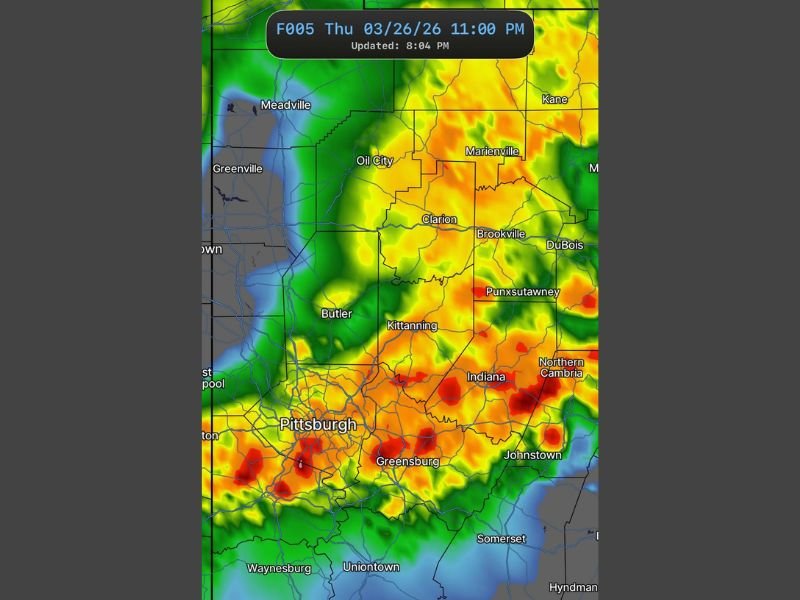
Storm Line Intensifying West of Pittsburgh
Radar imagery shows a widespread band of heavy rain and thunderstorms stretching across areas including Butler, Clarion, and Brookville. This line is pushing southeast and is expected to strengthen as it moves toward Pittsburgh.
Communities such as Kittanning, Indiana, and Punxsutawney are already seeing heavier rainfall and embedded storm activity.
Pittsburgh Metro Area Bracing for Peak Impact Window
The Pittsburgh metro area is expected to experience the worst of the storms during the 9 PM to 11 PM window. This period could bring the most intense rainfall, strongest winds, and highest risk for severe weather. Nearby areas including Greensburg and surrounding suburbs are also in the direct path of the advancing storm line.
Tornado Watch Remains in Effect
A tornado watch continues for the region through 11 PM, indicating that conditions are favorable for tornado development. While not every storm will produce a tornado, the environment supports the possibility of isolated rotation within stronger cells. Residents should remain prepared to act quickly if warnings are issued.
Heavy Rain and Strong Winds Likely
The primary threats with this system include:
- Intense downpours reducing visibility
- Strong wind gusts capable of causing damage
- Frequent lightning
Localized flooding could also develop in areas that receive repeated heavy rainfall.
Storms Continue Into Eastern Pennsylvania
As the system moves through Pittsburgh, it will continue tracking eastward toward areas including Johnstown and surrounding communities. The severe weather risk will shift east but remain active through the evening.
What Residents Should Expect Next
Residents across Pittsburgh, Butler, Greensburg, and nearby areas should remain alert during the evening hours as storms move in. Conditions may deteriorate quickly once the storm line arrives.
The tornado watch remains in effect until 11 PM, and additional warnings may be issued as storms intensify. Stay with NapervilleLocal.com for real-time updates, live radar coverage, and critical alerts as severe storms move across Pennsylvania.

I’ve lived in Naperville long enough to see how quickly our community changes — from new developments downtown to sudden shifts in our Midwest weather. Reporting on Naperville news and daily forecasts gives me the chance to keep neighbors informed about what really matters. My goal is simple: deliver clear, timely updates so you always know what’s happening in our city and what to expect from the skies above.