
Danville Vermilion County Storm Produces Baseball Size Hail Near Oakwood Bismarck Alvin With Destructive Conditions Along I 74 Corridor
DANVILLE, ILLINOIS — A dangerous severe thunderstorm is producing extremely large, destructive hail across Vermilion County, with reports indicating hail possibly larger than baseballs near Danville. The storm is intensifying rapidly as it tracks through communities along the I-74 corridor.
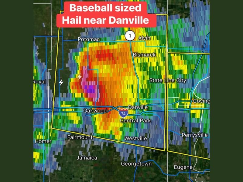
Massive Hail Core Develops Near Danville
Radar imagery shows an intense storm core centered near Danville, with the strongest reflectivity extending toward Oakwood and Bismarck. The storm has developed a powerful hail-producing core, highlighted by deep red and purple radar returns. Communities including Alvin and areas north toward Potomac are also within the zone of greatest impact.
Destructive Hail Threat Ongoing
The primary concern with this storm is the size of the hail, which may exceed baseball size in some locations. Hail of this magnitude can cause significant damage to:
- Vehicles and windshields
- Roofs and siding
- Crops and outdoor property
Residents in the path of this storm are urged to take shelter immediately.
Storm Impacting Key Communities Across Vermilion County
The storm is affecting a wide area including Danville, Oakwood, Westville, and surrounding communities. Areas near State Line City and Covington, Indiana may also see impacts as the storm continues moving east. Given the intensity of the storm, conditions can worsen quickly in any of these locations.
Rapidly Changing Conditions Along I 74
The storm is closely aligned with Interstate 74, creating dangerous travel conditions. Heavy rain, large hail, and lightning are all contributing to hazardous conditions for drivers. Visibility may drop suddenly, and road conditions could deteriorate quickly as hail accumulates.
What Residents Should Expect Next
Residents across Vermilion County and nearby areas should remain indoors and away from windows until the storm passes. Additional severe weather may follow, keeping conditions active through the evening.
This storm represents a significant severe weather event with the potential for serious damage. Stay with NapervilleLocal.com for urgent updates, live radar coverage, and critical alerts as this destructive storm continues across Illinois and into Indiana.

I’ve lived in Naperville long enough to see how quickly our community changes — from new developments downtown to sudden shifts in our Midwest weather. Reporting on Naperville news and daily forecasts gives me the chance to keep neighbors informed about what really matters. My goal is simple: deliver clear, timely updates so you always know what’s happening in our city and what to expect from the skies above.