
Alabama, Georgia, Tennessee, Mississippi Warm to 80s Next Week Before Early April Cold Snap Threat Around April 7–8
UNITED STATES — A dramatic temperature swing is shaping up across the Southeast as states like Alabama, Georgia, Tennessee, and Mississippi prepare for a surge into the 80s next week—followed by a potential cold snap that could arrive just days later in early April.
Forecast models and long-range outlooks suggest this warm-up will be short-lived, with growing signals pointing toward a cooler pattern developing around April 7–8.
Warm Surge Brings Early Taste of Summer
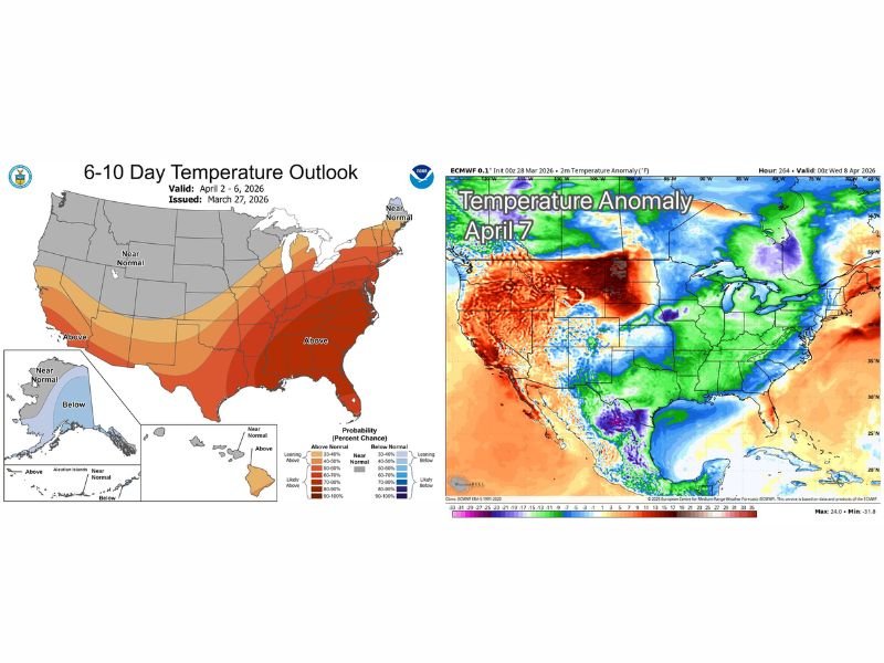
The 6–10 day outlook shows above-normal temperatures dominating much of the eastern United States, especially across the Southeast.
Alabama and surrounding states are expected to see highs climb into the 80s next week, creating ideal conditions for outdoor activity—and for many, the temptation to begin spring planting. This warm pattern is supported by strong ridging and southerly flow, allowing heat to build across the region.
Why Experts Urge Caution for Planting
Despite the upcoming warmth, meteorologists are advising residents not to rush into planting sensitive vegetation just yet.
Climatology shows that the Southeast often experiences a late-season cold snap during the first half of April. Even brief drops in temperature can bring frost or freezing conditions capable of damaging plants. In Alabama specifically, guidance suggests waiting until around mid-April before planting anything vulnerable.
Cold Snap Signals Emerging Around April 7–8
Global weather models are beginning to highlight a potential shift toward cooler air pushing into the eastern half of the country.
Temperature anomaly maps indicate below-normal conditions developing across parts of the Midwest, Ohio Valley, and potentially extending into the Southeast during the April 7–8 timeframe. While exact temperatures are still uncertain, the setup raises concerns about a late frost risk.
A Classic Spring Pattern Across the U.S.
This sequence—early warmth followed by a sudden cooldown—is a classic spring transition pattern in the United States.
Warm air surges northward ahead of developing systems, only to be replaced by colder air masses as the jet stream shifts and allows cooler air to spill southward.
These rapid swings can make forecasting impacts challenging, especially for agriculture and gardening.
What This Means Going Forward
Residents across Alabama, Georgia, Tennessee, and Mississippi should expect:
- Warm temperatures in the 80s next week
- Increasing spring-like conditions across the Southeast
- Potential for a notable cooldown around April 7–8
- Possible frost or freeze concerns depending on final temperatures
While the warm weather will feel like a true arrival of spring, the pattern suggests winter may still have one last brief return.
Stay with NapervilleLocal.com for ongoing forecast updates, temperature trend analysis, and alerts as this warm-up and potential early April cooldown continue to develop.

I’ve lived in Naperville long enough to see how quickly our community changes — from new developments downtown to sudden shifts in our Midwest weather. Reporting on Naperville news and daily forecasts gives me the chance to keep neighbors informed about what really matters. My goal is simple: deliver clear, timely updates so you always know what’s happening in our city and what to expect from the skies above.