
Pennsylvania Cold Saturday Brings 30s, 40s, Spotty Snow Showers Before Warm Surge Into 60s and 70s Early Next Week
PENNSYLVANIA — A brief return to winter-like conditions is unfolding across Pennsylvania this Saturday, with chilly temperatures, scattered clouds, and even a few spotty snow showers expected in parts of the state—especially in the northeast. The cold snap, however, will be short-lived as a significant warm-up is already on the horizon for early next week.
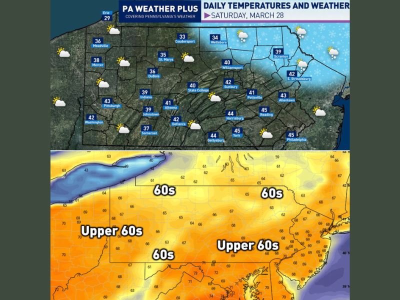
Cold Air Keeps Temperatures in the 30s and 40s
A cool northwesterly flow has settled across the region, holding afternoon high temperatures in the 30s and 40s statewide.
Cities like Pittsburgh, Altoona, and State College are seeing highs near the low 40s, while northeastern areas including Scranton and Williamsport remain even cooler, with some locations struggling to reach 40 degrees. The overall feel is more typical of late winter than the final days of March.
Snow Showers Possible in Northeastern Pennsylvania
An upper-level disturbance moving through the region may trigger a few scattered snow showers during the afternoon hours.
These are expected to be hit-or-miss and primarily confined to northeastern Pennsylvania. Due to relatively mild surface temperatures and increasing sun angle, no significant accumulation or major impacts are anticipated.
Weekend Chill Gives Way to Gradual Warm-Up
The cold blast is expected to linger through Saturday, but conditions will begin to improve by Sunday. Highs are forecast to climb into the 40s and 50s, offering a modest rebound from the colder start to the weekend.
Major Warm-Up Arrives Early Next Week
A much more noticeable shift arrives by Monday, when temperatures are expected to jump into the 60s across much of Pennsylvania.
By Tuesday and Wednesday, even warmer air moves in, with highs likely reaching into the 70s for many areas—a dramatic turnaround from the weekend chill.
What Residents Should Expect
Across Pennsylvania this weekend and into next week:
- Saturday: Highs in the 30s and 40s with a cold, breezy feel
- Spotty snow showers possible in northeastern areas
- Sunday: Gradual warming into the 40s and 50s
- Early next week: Highs surge into the 60s and 70s
This rapid temperature swing highlights the volatile nature of early spring weather in the Northeast. Stay with NapervilleLocal.com for the latest forecast updates, regional weather trends, and real-time alerts as Pennsylvania transitions from winter-like conditions to a spring warm-up.

I’ve lived in Naperville long enough to see how quickly our community changes — from new developments downtown to sudden shifts in our Midwest weather. Reporting on Naperville news and daily forecasts gives me the chance to keep neighbors informed about what really matters. My goal is simple: deliver clear, timely updates so you always know what’s happening in our city and what to expect from the skies above.