
Tampa, St Petersburg, Lakeland, Sarasota, Sebring See 30 MPH Wind Gusts Sunday With Breezy Conditions Continuing Into Monday Across Florida
FLORIDA — A windy start to Sunday is unfolding across central and west-central Florida, with gusts already reaching up to 30 mph and breezy conditions expected to persist through the day and into Monday.
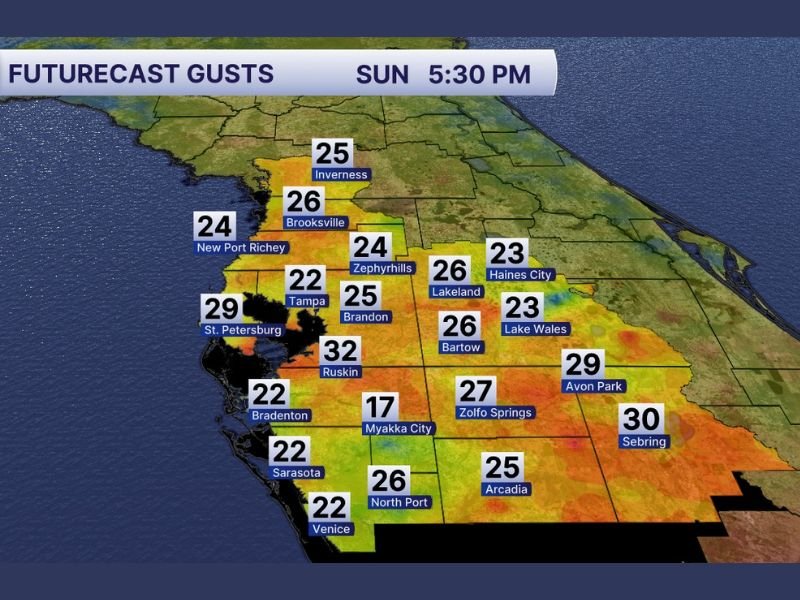
Forecast data shows sustained winds between 15 to 25 mph, with even stronger gusts impacting multiple cities across the Tampa Bay region and inland areas.
Strong Wind Gusts Impact Tampa Bay and Central Florida
Communities experiencing the strongest wind activity include:
- Tampa – gusts around 22 mph
- St. Petersburg – near 29 mph
- Lakeland – around 26 mph
- Sebring – near 30 mph
- Ruskin – up to 32 mph (highest observed)
Other areas such as Brooksville, Inverness, Zephyrhills, Sarasota, and Venice are also seeing gusts ranging from the low 20s to upper 20s.
Why Winds Are So Strong Today
The gusty conditions are being driven by a tight pressure gradient, which is accelerating airflow across the region.
This setup results in:
- Frequent wind gusts throughout the day
- Little relief even during afternoon hours
- Continued breezy conditions overnight
Unlike isolated wind events, this pattern supports consistent, widespread wind activity.
Winds Continue Into Monday
The breezy pattern does not end Sunday. Forecast guidance indicates:
- Sustained winds remain in the 15–25 mph range into Monday
- Occasional higher gusts will still be possible
- Gradual easing expected later Monday or beyond
Residents should prepare for extended periods of wind, not just brief gusty moments.
Impacts Residents Should Expect
While not severe, these winds can still cause noticeable impacts:
- Difficult driving conditions, especially for high-profile vehicles
- Loose outdoor objects being blown around
- Increased fire risk in dry areas
- Choppy conditions along coastal waters
Outdoor plans may still be manageable, but caution is advised.
What This Means for the Region
This wind event highlights a broader weather pattern shift, where breezy and active conditions are becoming more common across parts of the Southeast.
For now, the biggest takeaway is simple:
- Expect a windy Sunday across Florida
- Prepare for continued breezy conditions into Monday
- Stay aware of changing conditions, especially if traveling
Stay with NapervilleLocal.com for continued updates as Florida’s weather pattern evolves and conditions begin to settle early this week.

I’ve lived in Naperville long enough to see how quickly our community changes — from new developments downtown to sudden shifts in our Midwest weather. Reporting on Naperville news and daily forecasts gives me the chance to keep neighbors informed about what really matters. My goal is simple: deliver clear, timely updates so you always know what’s happening in our city and what to expect from the skies above.