
Birmingham, Montgomery, Huntsville, Mobile See 70s Today, 80s Tomorrow With Rain Returning Midweek and Easter Weekend Front Uncertainty Across Alabama
ALABAMA — A calm and warming stretch of weather is underway across the state today, but changes are already lining up for the middle and end of the week as rain chances gradually return and an uncertain Easter weekend system approaches.
Morning clouds are expected to give way to a mix of sun and clouds, allowing temperatures to climb comfortably into the 70s this afternoon. While a stray shower cannot be ruled out in far southeastern areas, most of Alabama will remain dry through the day.
Warm and Quiet Conditions Before Midweek Changes
Across cities like Birmingham, Montgomery, Huntsville, and Mobile, today’s weather remains relatively quiet with light south winds generally staying in the 5 to 10 mph range. The overall setup favors a pleasant and mild day with no organized weather concerns.
That quiet pattern holds into Monday as well, with dry conditions dominating for most of the day. However, by Monday evening, subtle changes begin as scattered showers and even an isolated thunderstorm may develop, lifting northward from the Gulf.
Temperatures Surge Into the 80s
As the warming trend continues, highs will climb into the 80s by Monday and beyond, signaling a more typical late spring feel across Alabama. Increasing moisture levels will also become noticeable, setting the stage for more frequent cloud cover and rain chances. This combination of warmth and moisture marks a transition toward a more active weather pattern.
Rain Chances Increase Through the Week
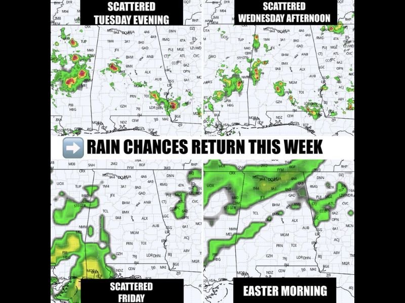
From Wednesday through Friday, scattered showers and a few thunderstorms are expected each day. However, no single day appears to bring widespread or continuous rainfall.
Instead, the pattern favors:
- Intermittent showers
- Periods of dry weather between systems
- Limited overall rainfall coverage
Importantly, this pattern is not expected to significantly reduce ongoing drought conditions, as rainfall remains uneven and scattered.
Easter Weekend Brings a Key Forecast Question
Attention then turns to the Easter weekend, where a developing cold front approaches from the west.
Early indications suggest:
- Saturday: Scattered showers possible, but more organized rain remains west of Alabama
- Sunday (Easter): The cold front moves closer, bringing increasing rain chances
The biggest uncertainty lies in how this system behaves. If the front pushes fully through the state, cooler air will follow, potentially dropping morning lows back into the 40s by early next week. If it stalls, warmer and more humid conditions could linger longer.
No Severe Weather Expected, But Pattern Worth Watching
At this time, the system is expected to weaken as it arrives, meaning organized severe weather is not anticipated. Still, given the time of year, the situation will continue to be monitored closely for any changes.
What This Means for Alabama Residents
The upcoming stretch highlights a typical spring transition across the region:
A warm and pleasant start gives way to increasing humidity and scattered rain chances, followed by a potential cooldown depending on how the Easter weekend system evolves.
Residents can enjoy the dry and mild conditions early in the week while preparing for a more unsettled pattern heading into the latter half of the week. Stay with NapervilleLocal.com for continued updates as Alabama’s spring weather pattern develops and the Easter weekend forecast becomes clearer.

I’ve lived in Naperville long enough to see how quickly our community changes — from new developments downtown to sudden shifts in our Midwest weather. Reporting on Naperville news and daily forecasts gives me the chance to keep neighbors informed about what really matters. My goal is simple: deliver clear, timely updates so you always know what’s happening in our city and what to expect from the skies above.