
Alabama Birmingham, Montgomery, Mobile and Huntsville Heat Up Into Mid 80s This Week Before Weekend Cold Front Brings Rain and Cooler Air
ALABAMA — A strong warming trend is taking hold across the state this week, with temperatures climbing into the 80s statewide through Friday before a weekend cold front introduces rain chances and a slight cooldown.
Rapid Warm-Up Across the State Through Midweek
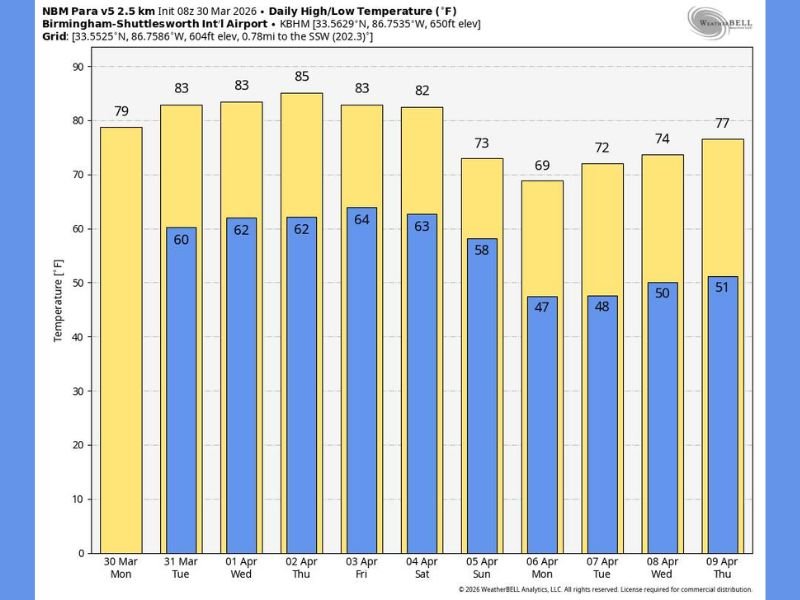
Afternoon temperatures will surge quickly, especially across southern Alabama where highs are expected to reach the low 80s today, while northern areas including Huntsville and Birmingham settle into the upper 70s.
By Tuesday through Friday, nearly the entire state—from Mobile and Montgomery to Birmingham and Huntsville—will consistently see highs in the 80s, marking a significant shift toward early summer-like warmth. Overnight lows will also trend upward, generally staying in the low to mid 60s, adding to the mild feel across Alabama.
Mostly Dry Pattern With Only Spotty Rain Chances
Despite the warming trend, rainfall will remain limited for much of the week. Most of Alabama will stay dry today, with only a small chance of a brief shower across the southern portion of the state.
On Tuesday, a few isolated showers may develop, mainly focused across southeast Alabama, but coverage will remain scattered. From Wednesday through Friday, rain chances increase slightly statewide, though showers are expected to be:
- Widely spaced
- Light and spotty
- Not enough to significantly impact drought conditions
- Weekend Pattern Shift Brings More Organized Rain
By the weekend, a more noticeable change arrives.
Saturday will remain warm and mostly quiet, with highs ranging between 80 and 85 degrees, though a few isolated showers cannot be ruled out.
However, Sunday marks a more organized weather shift, as a cold front moves through Alabama, bringing a band of showers and thunderstorms across the state.
Severe Risk Remains Low, Rainfall Totals Limited
At this time, the overall setup suggests low potential for severe weather, as the main atmospheric dynamics remain positioned farther north.
Rainfall totals are expected to stay relatively modest, with most areas receiving around half an inch or less. Behind the front, cooler air will begin to filter in, especially across northern Alabama.
Cooler Air Returns Early Next Week
Following the weekend front, temperatures will ease back into the low to mid 70s across northern Alabama, while southern areas remain slightly warmer.
Nighttime temperatures will drop into the 40s early next week, signaling a brief return to more typical spring conditions. Despite the cooler air, frost concerns currently remain low, offering some reassurance for early planting and outdoor plans.
What This Means Going Forward
Alabama is entering a classic spring transition pattern, with warm, dry days dominating the week before a weekend system introduces rain and a mild cooldown.
Residents should take advantage of the warm stretch but stay alert for Sunday’s rain and storm chances, especially for travel or outdoor plans. Stay with NapervilleLocal.com for continued weather updates as this warming trend and weekend system develop further across Alabama and the Southeast.

I’ve lived in Naperville long enough to see how quickly our community changes — from new developments downtown to sudden shifts in our Midwest weather. Reporting on Naperville news and daily forecasts gives me the chance to keep neighbors informed about what really matters. My goal is simple: deliver clear, timely updates so you always know what’s happening in our city and what to expect from the skies above.