
Alabama Birmingham and Tuscaloosa Face Rainy Easter Sunday After Warm Week With Showers and Storm Chances Through Friday
BIRMINGHAM, ALABAMA — A warm and mostly dry stretch of weather across Alabama this week is expected to take a wetter turn just in time for Easter Sunday, with rain likely across much of the state and potential disruptions to outdoor plans.
While the timing may not be ideal for holiday activities, the incoming rain could provide much-needed moisture following several dry days.
Warm and Mostly Dry Conditions Through Midweek
From Tuesday through Thursday, Alabama will experience generally warm temperatures and limited rainfall, with highs climbing into the low to mid-80s across much of the state.
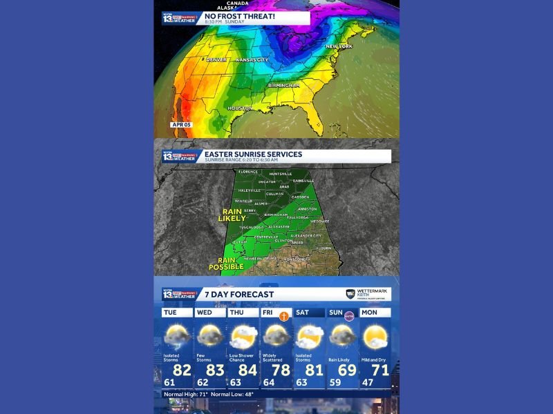
Forecast highs include:
- Around 82 degrees Tuesday with isolated storms
- Near 83 degrees Wednesday with only a few storms
- Up to 84 degrees Thursday with just a low chance of showers
Despite occasional storm chances, most areas are expected to remain dry for much of this period, with only brief and scattered activity.
Friday Brings Uncertainty With Scattered Showers
By Friday, conditions become more unsettled, though rainfall coverage remains inconsistent.
The forecast suggests:
- Widely scattered showers and storms
- Some areas receiving rain while others stay dry
- Temperatures cooling slightly to the upper 70s
This “hit-or-miss” pattern makes it difficult to pinpoint exact impacts, but signals a gradual transition toward a wetter setup.
Easter Weekend Rain Likely Across the State
The most significant shift arrives over the weekend, particularly on Easter Sunday, which is expected to be the wettest day of the entire stretch.
Rain is likely across:
- Birmingham
- Tuscaloosa
- Florence
- Gadsden and Anniston regions
Forecast guidance indicates widespread rain during the morning hours, potentially affecting sunrise services and outdoor gatherings. Southern portions of the state may see slightly lower coverage, but rain remains possible across a broad area.
Cooler Air Follows Holiday Weekend
After the weekend system moves through, cooler air will settle into the region, though temperatures will remain well above freezing, eliminating any frost concerns.
By Monday:
- Conditions turn mild and dry
- Highs settle near the low 70s
- Skies improve, offering a calmer start to the following week
What This Means for Residents and Holiday Plans
Residents planning outdoor Easter activities should prepare for:
- Wet conditions Sunday morning
- Possible delays or adjustments for outdoor services
- Periods of steady rain rather than isolated showers
While the timing is inconvenient, the rain could benefit areas that have remained dry during the week.
Warm Start, Wet Finish to the Week
The overall pattern shows a warm and mostly dry week transitioning into a wetter Easter weekend, followed by a mild and calmer start next week.
Weather conditions will continue to be monitored as the weekend system approaches Alabama. Stay with NapervilleLocal.com for continued updates on holiday weather and regional forecasts.

I’ve lived in Naperville long enough to see how quickly our community changes — from new developments downtown to sudden shifts in our Midwest weather. Reporting on Naperville news and daily forecasts gives me the chance to keep neighbors informed about what really matters. My goal is simple: deliver clear, timely updates so you always know what’s happening in our city and what to expect from the skies above.