
Texas and Oklahoma Face Wednesday Night Severe Storm Threat With Large Hail Damaging Winds and Isolated Tornado Risk From Abilene to Oklahoma City
ABILENE, TEXAS — A round of severe to strong thunderstorms is expected to develop Wednesday evening across parts of Texas and Oklahoma, bringing the potential for large hail, damaging winds, and even an isolated tornado risk through the night.
The most intense storms are expected across western and central Texas before gradually weakening as they move east overnight.
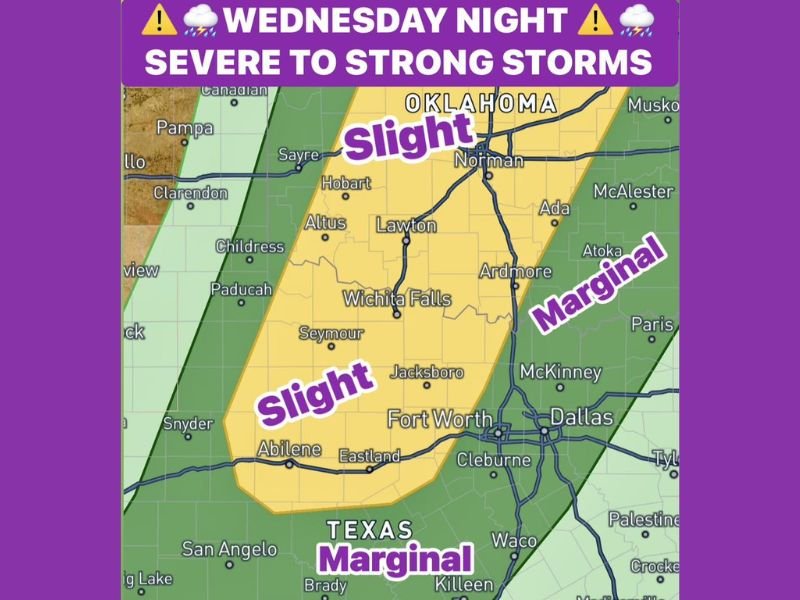
Slight Risk Zone Covers West and Central Texas Into Oklahoma
Forecast data highlights a Slight Risk (Level 2) area stretching from Abilene through Wichita Falls and into parts of southern Oklahoma, including areas near Lawton and Norman.
This corridor is expected to see the strongest storm development between 6 PM and 11 PM, when atmospheric conditions will be most favorable.
Primary threats in this zone include:
- Large to very large hail, potentially exceeding severe limits
- Damaging wind gusts up to 65 mph
- Isolated tornado potential in stronger storm cells
- Frequent lightning and localized heavy rainfall
Cities such as Abilene, Wichita Falls, Lawton, and surrounding communities are in the highest concern area for severe impacts.
Storms Expected to Weaken East of I 35 Overnight
As storms track eastward later in the night, they are expected to gradually weaken, particularly east of the Interstate 35 corridor, which includes major metro areas like Dallas and Fort Worth.
However, even weakening storms could still produce:
- Strong wind gusts
- Brief heavy rain
- Frequent lightning
Residents in these areas should remain alert even if the most intense phase stays farther west.
Marginal Risk Extends Across North Texas Overnight
A broader Marginal Risk (Level 1) area covers much of North Texas, including the Dallas–Fort Worth region, with storm activity expected between midnight and 4 AM.
Within this zone, impacts are expected to be less intense but still notable:
- Small hail ranging from pea to quarter size
- Wind gusts between 40 and 60 mph
- Scattered lightning and pockets of heavy rain
This overnight timing increases the importance of staying weather-aware, as storms may arrive while many residents are asleep.
Timing and Key Impacts to Watch
The overall storm timeline is expected to unfold in two main phases:
- Evening (6 PM to 11 PM): Strongest storms across west and central Texas into Oklahoma
- Overnight (12 AM to 4 AM): Weaker but still impactful storms moving into North Texas
The evolving nature of the system means conditions could change quickly depending on storm development and movement.
Residents Urged to Stay Alert Overnight
With multiple hazards possible, residents across Texas and Oklahoma should prepare for changing weather conditions, especially during evening and overnight hours.
Key precautions include:
- Monitoring weather alerts before going to sleep
- Securing outdoor items ahead of strong winds
- Being prepared for sudden hail or lightning events
Active Storm Pattern Continues Across Southern Plains
This storm setup is part of a broader active weather pattern across the Southern Plains, with continued chances for storms in the coming days.
Conditions will continue to be monitored as severe weather develops across Texas and Oklahoma Wednesday night. Stay with NapervilleLocal.com for continuing updates and real-time severe weather coverage.

I’ve lived in Naperville long enough to see how quickly our community changes — from new developments downtown to sudden shifts in our Midwest weather. Reporting on Naperville news and daily forecasts gives me the chance to keep neighbors informed about what really matters. My goal is simple: deliver clear, timely updates so you always know what’s happening in our city and what to expect from the skies above.