
Oklahoma Faces Dangerous Tornado Zone Wednesday With Supercells Bringing Golf Ball Size Hail 75 MPH Winds and Evening Tornado Risk From Lawton to Oklahoma City
OKLAHOMA CITY, OKLAHOMA — A significant severe weather setup is expected to unfold across Oklahoma on Wednesday, with a defined tornado risk zone stretching across central and southern parts of the state as powerful storms develop through the afternoon and evening.
This marks another round of severe weather threats this week, with conditions becoming increasingly favorable for dangerous supercells.
Tornado Risk Zone Expands Across Central and Southern Oklahoma
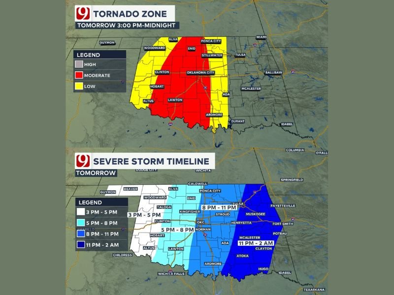
Forecast data shows a high-impact corridor extending from Lawton through Oklahoma City and up toward Enid and Ponca City, where the greatest tornado potential is expected.
Cities within this zone include:
- Oklahoma City
- Lawton
- Enid
- Clinton
- Ardmore
Surrounding areas, including Stillwater and parts of western Oklahoma, remain under a broader risk where severe storms are still likely but slightly less intense.
Storm Timing Focused From Afternoon Into Midnight
The primary window for severe weather is expected between 3 PM and midnight, with storms developing first in western Oklahoma before moving eastward.
Forecast timing suggests:
- 3 PM to 5 PM: Initial storm development in western Oklahoma
- 5 PM to 8 PM: Intensification as storms move into central areas, including Oklahoma City
- 8 PM to 11 PM: Peak severe threat with tornado potential increasing
- Late evening into midnight: Storms continue eastward with ongoing impacts
This timeline highlights an extended period of concern, particularly during evening hours.
Supercells Capable of Large Hail and Damaging Winds
The incoming system is expected to tap into rich Gulf moisture and increasing wind shear — two key ingredients for rotating supercells.
Primary threats include:
- Large hail, potentially as big as golf balls
- Damaging wind gusts up to 75 mph
- Frequent lightning and heavy rain pockets
These hazards could develop quickly as storms strengthen across the region.
Tornado Potential Increases Into Evening Hours
While tornado development is not guaranteed early in the day, conditions are expected to become more favorable as the evening progresses.
Strengthening low-level winds combined with increasing instability could allow some storms to begin rotating more efficiently, raising the risk of tornado formation later in the evening. Residents are urged to remain especially alert during this time window.
Why This Setup Is Concerning
A dryline setting up near the Oklahoma–Texas border will act as a trigger point for storm development. As storms form along this boundary and move east, they will enter a more unstable environment, allowing them to intensify rapidly. This type of setup is well-known for producing strong, rotating storms capable of multiple severe hazards.
Residents Urged to Prepare Ahead of Severe Weather
With multiple threats possible, residents across Oklahoma should take precautions ahead of Wednesday’s storms:
- Identify a safe shelter location in advance
- Ensure multiple ways to receive weather alerts
- Stay updated on changing conditions throughout the day
Preparedness will be critical as storms could develop quickly and intensify with little warning.
Active Severe Weather Pattern Continues
This event is part of an ongoing active weather pattern across the Southern Plains, with multiple rounds of severe weather expected this week.
Conditions will continue to be monitored as storms develop across Oklahoma on Wednesday. Stay with NapervilleLocal.com for continuing severe weather coverage and real-time updates.

I’ve lived in Naperville long enough to see how quickly our community changes — from new developments downtown to sudden shifts in our Midwest weather. Reporting on Naperville news and daily forecasts gives me the chance to keep neighbors informed about what really matters. My goal is simple: deliver clear, timely updates so you always know what’s happening in our city and what to expect from the skies above.