
Pennsylvania Sees Sharp Temperature Split From 30s in Erie to 80s in Philadelphia With Cold Front Triggering Showers and Strong Storms Near Harrisburg
HARRISBURG, PENNSYLVANIA — A dynamic spring weather pattern is unfolding across Pennsylvania today, with a sharp temperature contrast across the state and a cold front triggering showers and potential strong storms during the afternoon and evening hours.
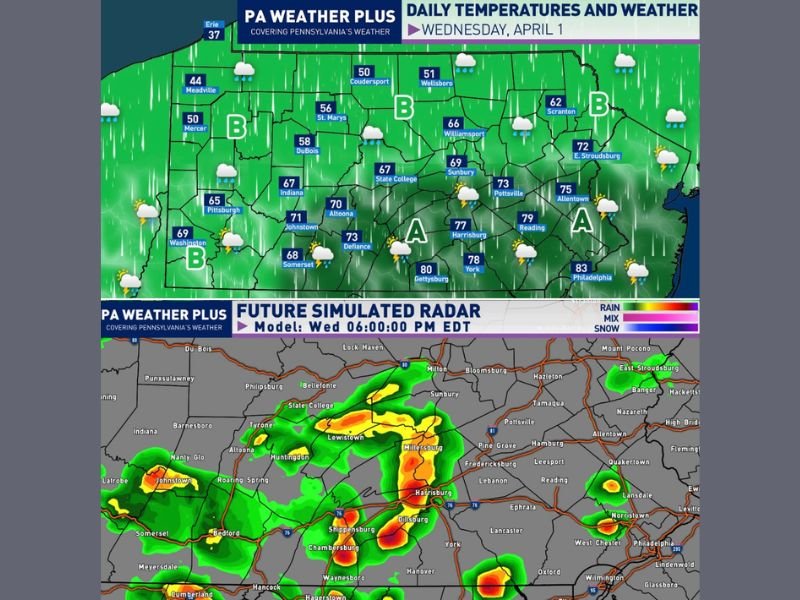
Temperatures will range dramatically from near winter-like conditions in the northwest to early summer warmth in the southeast.
Major Temperature Divide Across Pennsylvania
Forecast data shows a striking contrast in temperatures across the state:
- Erie and northwestern Pennsylvania remain in the upper 30s to mid-40s
- Central areas including State College and Williamsport range through the 60s
- Harrisburg and York climb into the upper 70s
- Southeastern cities like Philadelphia could reach the low 80s
This sharp gradient is driven by a cold front moving southward, dividing cooler air to the north from much warmer air to the south.
Showers and Storms Develop Along the Front
As the front progresses through the state, it will spark numerous showers and scattered thunderstorms, especially during the afternoon.
Two distinct zones are expected:
Area A Includes Central and Southeastern Pennsylvania
This region, including Harrisburg, York, Reading, and Philadelphia, has the best chance for:
- Pop-up showers and thunderstorms throughout the day
- Stronger storms after 3 PM, when instability peaks
- Gusty winds and isolated hail in stronger cells
Radar projections suggest storms could intensify near Harrisburg toward the evening, producing heavier rainfall and stronger impacts.
Area B Covers Northern and Western Pennsylvania
Areas north of Interstate 80, including Erie, Meadville, and parts of central Pennsylvania, will see:
- Steadier showers and occasional thunder throughout the day
- Less severe intensity but more consistent rainfall
These areas will remain cooler and more stable compared to the south.
Timing of Strongest Storms Focused Late Afternoon
The most active period is expected:
- After 3 PM into the evening hours
- With storms developing and strengthening along the cold front
Because storms will be scattered, some areas may see heavier impacts while others experience only light rain.
Key Impacts Residents Should Watch
Across Pennsylvania, the main concerns include:
- Gusty winds in stronger storms
- Isolated hail potential
- Heavy downpours in localized areas
While not a widespread severe outbreak, a few storms could become strong, particularly in central and southeastern regions.
Rapidly Changing Conditions Across the State
Today’s weather highlights how quickly conditions can shift across Pennsylvania, with some areas experiencing chilly rain while others deal with warm, unstable air and thunderstorms.
Residents should be prepared for changing conditions throughout the day and evening.
A Divided Weather Day Across Pennsylvania
The overall pattern shows a split weather setup with cooler, steady rain in the north and warmer, storm-prone conditions in the south, driven by a moving cold front.
Conditions will continue to be monitored as storms develop across Pennsylvania today.
Stay with NapervilleLocal.com for continued updates and regional weather coverage.

I’ve lived in Naperville long enough to see how quickly our community changes — from new developments downtown to sudden shifts in our Midwest weather. Reporting on Naperville news and daily forecasts gives me the chance to keep neighbors informed about what really matters. My goal is simple: deliver clear, timely updates so you always know what’s happening in our city and what to expect from the skies above.