
Ohio Cleveland Toledo Columbus and Dayton Face Scattered Thunderstorm Risk Today With Isolated Strong Cells Possible South of I 70
OHIO — An unsettled weather pattern is continuing across the state today as a slow-moving frontal boundary drifts south, setting the stage for scattered thunderstorms throughout the day, with a few potentially turning strong — especially across southern parts of the region.
While this will not be a complete washout, conditions remain active enough that residents across multiple cities should stay alert.
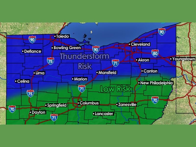
Thunderstorm Risk Spreads Across Northern and Central Ohio
A broad thunderstorm risk zone stretches across much of northern and central Ohio, including:
- Cleveland
- Toledo
- Bowling Green
- Akron
- Canton
- Mansfield
- Lima
These areas are expected to see periodic showers and thunderstorms, but coverage will remain scattered, meaning some communities may see little to no rain while others experience brief downpours.
Stronger Storm Potential Focused South of I 70
The more notable concern lies farther south, where a low-end severe risk has been outlined. This includes:
- Columbus
- Springfield
- Dayton
- Lancaster
- Zanesville
If instability builds during the afternoon, a few storms in these areas could briefly intensify, producing:
- Damaging wind gusts
- Small hail
- Heavy rain in short bursts
However, this is expected to remain isolated rather than widespread.
Timing Through the Afternoon and Evening
Storm development will follow a familiar spring pattern:
- Late morning to early afternoon: Initial scattered showers
- Afternoon into evening: Peak window for stronger storms
- Activity gradually tapers off later tonight
Because storms will be hit-or-miss, conditions can vary significantly from one town to another.
Why This Isn’t a Major Severe Outbreak
Despite the presence of storms, several limiting factors are keeping the overall threat lower:
- Instability remains somewhat limited
- Storm coverage is scattered, not organized
- The frontal boundary is slow-moving and weakening
This setup supports quick-hitting storms rather than long-lived severe systems.
What Residents Should Watch For
Even with a lower-end setup, it only takes one storm to create brief impacts. Residents should be aware of:
- Sudden downpours during commutes
- Lightning and brief gusty winds
- Localized hail in stronger cells
Communities along and south of Interstate 70 should pay closest attention during the afternoon hours.
A Busy Stretch of Weather Continues
This pattern reflects a broader trend of active spring weather across the region, with multiple days featuring scattered storm chances rather than a single major event.
For today, the key message is simple: not everyone will see storms, but a few locations could get hit with brief, stronger activity. Stay with NapervilleLocal.com for continuing weather updates and local impact coverage.

I’ve lived in Naperville long enough to see how quickly our community changes — from new developments downtown to sudden shifts in our Midwest weather. Reporting on Naperville news and daily forecasts gives me the chance to keep neighbors informed about what really matters. My goal is simple: deliver clear, timely updates so you always know what’s happening in our city and what to expect from the skies above.