
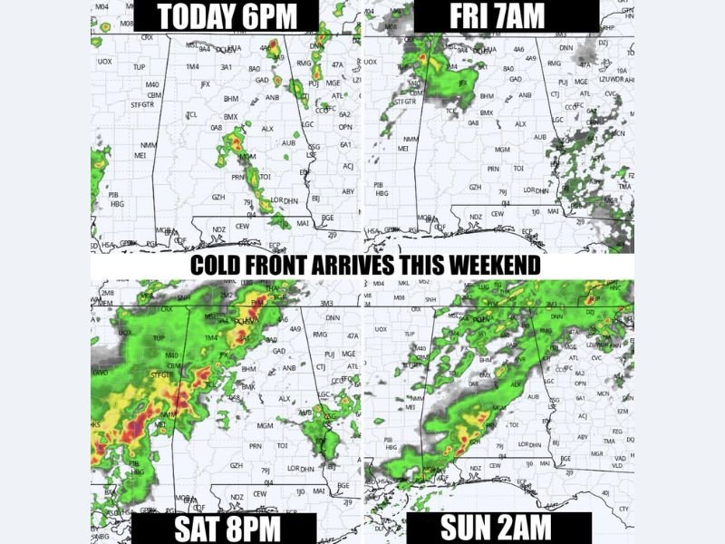
After 2 PM Today: Isolated Storms Develop Across Alabama Before Weekend Cold Front Brings Widespread Rain
ALABAMA — Warm, humid, and slightly unsettled conditions are setting the stage for a few isolated showers and storms later today, followed by a more organized round of rain this weekend as a cold front moves through the state. While today’s activity remains limited, attention shifts to Saturday evening into Sunday for more widespread rainfall.
Isolated Storms Possible This Afternoon
Through the morning and early afternoon, conditions remain mostly warm and humid with only limited rain coverage.
After 2:00 PM, a few popup showers or isolated thunderstorms may develop across parts of the state. However, these will be scattered and not expected to become widespread or severe.
Friday Brings Shifting Rain Chances
Rain chances remain isolated overall on Friday, but the timing shifts compared to today.
The best chances for rain will occur:
- Early Friday morning
- Again later in the day
Temperatures will stay warm, with highs reaching into the 80s, supported by a mild southerly wind.
Weekend Cold Front Brings Widespread Rain
The main weather system arrives this weekend as a cold front pushes into Alabama.
- Saturday evening: Rain begins entering western parts of the state
- Overnight into Sunday morning: Rain spreads statewide
- Sunday midday: Lingering rain, especially in eastern areas
Some storms may develop along the front, but organized severe weather is not expected at this time. Rainfall totals could exceed 1 inch in some areas, particularly where storms persist longer.
Sunday Improves With Gradual Clearing
By Sunday afternoon, conditions are expected to slowly improve as rain moves out and breaks in the clouds begin to develop.
This could allow for better outdoor conditions later in the day, including planned Easter activities. However, morning hours may still be wet, especially for early services around sunrise.
Cooler and Drier Weather Returns Next Week
Behind the cold front, a noticeable cooldown is expected:
- Sunday highs: Drop into the 60s
- Monday morning: Cooler start with temperatures in the 40s
- Early next week: Dry and more stable weather returns
This marks a shift away from the warm, humid pattern currently in place. Stay with NapervilleLocal.com for the latest weather updates and local forecast coverage.

I’ve lived in Naperville long enough to see how quickly our community changes — from new developments downtown to sudden shifts in our Midwest weather. Reporting on Naperville news and daily forecasts gives me the chance to keep neighbors informed about what really matters. My goal is simple: deliver clear, timely updates so you always know what’s happening in our city and what to expect from the skies above.