
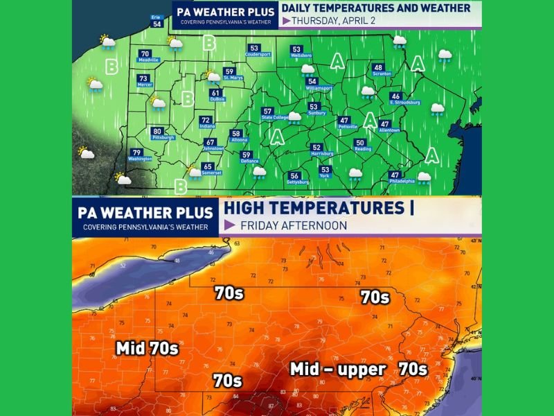
Today: Sharp Temperature Split Across Pennsylvania With 40s and 50s East While Western Areas Surge Into 70s
PENNSYLVANIA — A strong temperature divide is setting up across the state today, bringing much cooler conditions to central and eastern areas while western regions warm significantly. This contrast is driven by lingering cold air in the east and a warm front pushing through western parts of the state.
Central and Eastern Areas Stay Cool and Damp
Much of central and eastern Pennsylvania will remain under the influence of colder air, keeping temperatures limited to the upper 40s through mid-50s.
Periods of drizzle and light rain are expected throughout the day, especially across areas marked with steadier precipitation coverage. Conditions will remain cloudy and damp for much of the region.
Western Pennsylvania Warms Significantly
In contrast, western Pennsylvania will see a major warm-up as a warm front moves through during the morning and early afternoon.
Temperatures in these areas will climb into the 70s, with some locations nearing 80 degrees, especially around Pittsburgh. Skies will also trend partly cloudy as conditions improve.
Noticeable West-to-East Temperature Gradient
The difference in air masses will create a tight temperature gradient across the state, with a sharp transition from warm conditions in the west to cooler, rainy weather in the east. This contrast will be one of the defining features of today’s weather setup.
Rain Chances Vary by Region
- Area A: Ongoing drizzle and light rain showers throughout the day
- Area B: Rain during the morning into midday, followed by partial clearing
These varying conditions highlight how uneven weather will be across different parts of Pennsylvania.
Warmer Weather Returns Tomorrow
Conditions improve heading into tomorrow as the warm front lifts through the entire state. Temperatures are expected to reach the low to upper 70s statewide, with mostly sunny skies developing for a much more pleasant end to the week.
Weekend Brings Another Change
The warmer pattern will continue into Saturday before another cold front arrives, bringing rain showers and cooler temperatures just in time for Easter Sunday.
Overall, today’s weather showcases a split pattern with cool, wet conditions in the east and warm, improving weather in the west, before a statewide warm-up takes hold. Stay with NapervilleLocal.com for the latest weather updates and local forecast coverage.

I’ve lived in Naperville long enough to see how quickly our community changes — from new developments downtown to sudden shifts in our Midwest weather. Reporting on Naperville news and daily forecasts gives me the chance to keep neighbors informed about what really matters. My goal is simple: deliver clear, timely updates so you always know what’s happening in our city and what to expect from the skies above.