
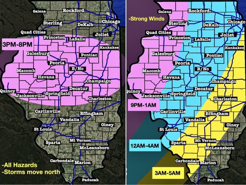
3 PM to 8 PM: First Round of Severe Storms Targets Central Illinois With Tornado, Hail and Wind Risk Before Late-Night Line
ILLINOIS — A dynamic and potentially impactful weather day is setting up across the state as two separate rounds of storms are expected to move through. The first round arrives this afternoon as a warm front lifts north, creating an environment capable of producing severe storms. While activity will be scattered, any storm that develops could quickly intensify. A second round follows overnight, bringing additional concerns even as storms begin to weaken.
First Round Develops This Afternoon Across Central Areas
The initial round of storms is expected to develop between 3:00 PM and 8:00 PM, mainly across central portions of the state. This timeframe is critical because the atmosphere will be most unstable as warmer, more humid air moves in.
Storms that form during this period may become strong quickly, with the potential to produce tornadoes, golf ball-sized hail, and damaging wind gusts. Even though not everyone will see storms, the isolated nature increases the risk that individual storms could become more intense without much competition nearby.
Areas North of I-72 to I-80 Should Stay Alert
The zone of greatest concern stretches north of I-72 up toward I-80, where the best combination of instability and wind dynamics is expected. This region will be closest to the lifting warm front, which often serves as a trigger point for severe storm development.
Communities in this corridor, including Peoria, Bloomington-Normal, LaSalle, and surrounding areas, should remain especially alert during the late afternoon and early evening hours. Conditions in this zone may allow storms to rotate more efficiently, increasing the risk for severe impacts.
Second Round Arrives Overnight From the West
After the first round exits or weakens, attention turns to a second system moving in from the west. This round will take the form of a decaying squall line advancing out of Missouri and Iowa during the nighttime hours.
Although this line will be weakening as it moves east, it will still carry enough energy to produce damaging wind gusts and possibly brief tornado spin-ups, especially in areas closer to the western edge of the state.
Strongest Overnight Risk Near Mississippi River
The highest overnight storm potential will remain concentrated near the Mississippi River, where storms will still be relatively stronger before gradually weakening as they push farther east.
As the line progresses across the state, storm intensity is expected to decrease, but pockets of stronger wind and heavy rain may still occur, particularly in western and central areas.
Overnight Timing From Late Evening Into Early Morning
The second round will move steadily across the state overnight, with impacts spreading from west to east:
- 9 PM to 1 AM: Storms enter western areas
- 12 AM to 4 AM: Activity reaches central regions
- 3 AM to 5 AM: Storms push into eastern areas
Because much of this activity occurs overnight, it is important for residents to have reliable ways to receive weather alerts while asleep.
Pattern Calms Down After Today
Once these two rounds of storms pass, the overall weather pattern is expected to settle down. A quieter stretch of weather is likely to follow, bringing more stable conditions and a break from active storm threats after today. Stay with NapervilleLocal.com for the latest weather updates and local forecast coverage.

I’ve lived in Naperville long enough to see how quickly our community changes — from new developments downtown to sudden shifts in our Midwest weather. Reporting on Naperville news and daily forecasts gives me the chance to keep neighbors informed about what really matters. My goal is simple: deliver clear, timely updates so you always know what’s happening in our city and what to expect from the skies above.