
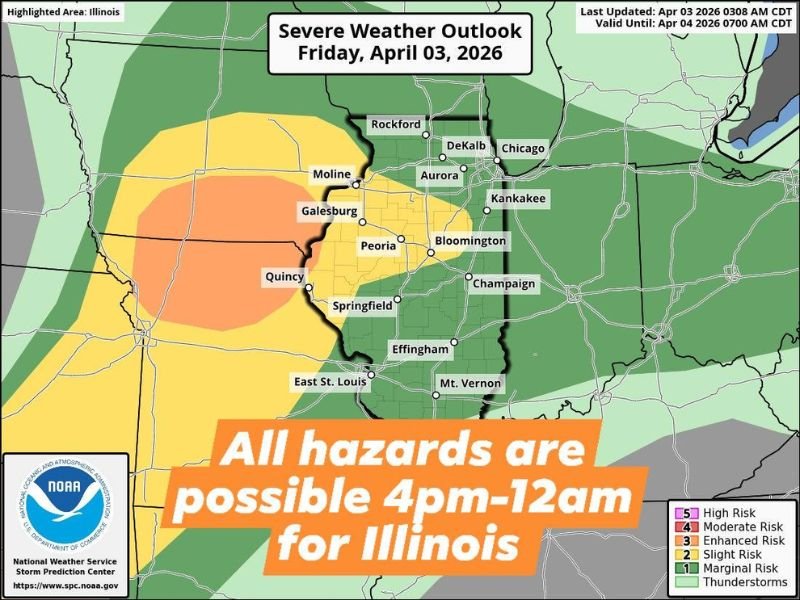
3 PM to Midnight: Severe Storm Threat Builds Across Illinois With Tornado Risk Early and Damaging Winds Overnight
ILLINOIS — A two-phase severe weather setup is expected today as storms develop this afternoon and continue into the overnight hours. Conditions will start dry, but a warm front lifting north across central Illinois will trigger thunderstorms capable of producing multiple hazards later in the day.
Dry Start Before Storms Develop This Afternoon
The day will begin on a quiet note with dry conditions across much of the state. However, this calm start will not last long as atmospheric conditions begin to change heading into the afternoon.
As the warm front lifts north, it will create a favorable environment for storm development, especially across central parts of Illinois.
First Round Brings Tornado Risk Between 3 PM and 9 PM
The first round of storms is expected to develop between 3:00 PM and 4:00 PM and continue through the early evening.
During this period, storms may become severe and capable of producing:
- Tornadoes
- Large hail
- Damaging winds
The highest tornado risk will be along and south of I-80 into central Illinois, where storms will be closest to the warm front and better instability.
Storms Shift to Damaging Wind Threat After 8 PM
As the evening progresses, the primary threat will transition away from tornadoes toward damaging winds.
After approximately 8:00 PM to 9:00 PM, storms are expected to organize into a more linear system, increasing the potential for strong wind gusts as they move through.
Heavy Storms Continue Overnight Across Northern Areas
A line of thunderstorms will push across northern Illinois from around 9:00 PM through 3:00 AM Saturday.
These storms may still produce:
- Strong winds
- Heavy rainfall
- Occasional lightning
Lingering showers are expected to continue into Saturday morning as the system gradually exits the region.
Storms Track Northeast Through the State
Storms developing across central Illinois during the afternoon will move northeast, bringing impacts into additional areas later in the evening. This movement means areas further north should monitor conditions closely as storms approach after initially forming farther south.
Two-Stage Event Requires All-Day Awareness
Today’s setup highlights a two-stage severe weather event, with an initial tornado risk followed by a more widespread damaging wind threat overnight.
Residents are encouraged to stay alert throughout the day and have multiple ways to receive warnings, especially during the overnight hours when storms may be ongoing. Stay with NapervilleLocal.com for the latest weather updates and local forecast coverage.

I’ve lived in Naperville long enough to see how quickly our community changes — from new developments downtown to sudden shifts in our Midwest weather. Reporting on Naperville news and daily forecasts gives me the chance to keep neighbors informed about what really matters. My goal is simple: deliver clear, timely updates so you always know what’s happening in our city and what to expect from the skies above.