
Easter Weekend: Warm and Mostly Dry Across Florida Before Showers Return Sunday and Cooler Air Next Week
FLORIDA — A warm and mostly dry Easter weekend is expected across the state, with only limited rain chances early before showers become more noticeable later on Sunday. A cold front arriving Monday will bring scattered storms and a shift toward cooler temperatures through midweek.
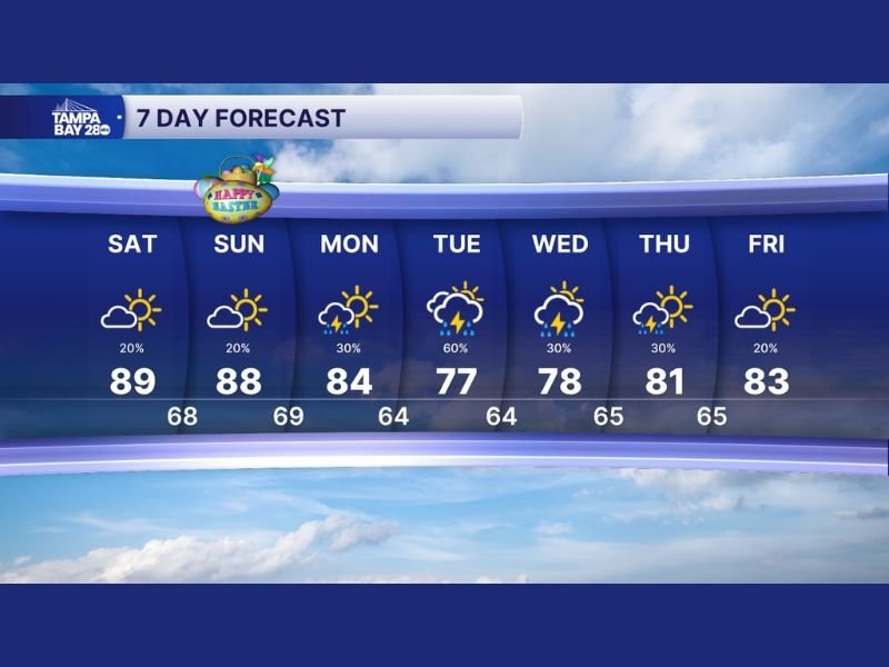
Saturday Stays Warm and Largely Dry
Saturday will bring pleasant conditions across Florida, with highs climbing near 89°F and only a slight chance of isolated showers. Most areas will stay dry, making it the better day for outdoor plans and Easter weekend activities. Humidity will remain moderate, but sunshine and warm temperatures will dominate throughout the day.
Easter Sunday Brings Increasing Shower Chances
Conditions begin to shift on Easter Sunday as scattered showers develop, especially in areas south of the I-4 corridor. While rain chances remain relatively low at around 20%, clouds will increase and brief showers could interrupt outdoor plans. Temperatures will stay warm, reaching around 88°F, but the increasing moisture signals a more active pattern ahead.
Storm Chances Increase With Cold Front on Monday
A cold front approaching from the west will bring a higher chance of showers and thunderstorms on Monday. Rain chances rise to around 30%, with some storms potentially producing brief downpours and lightning. High temperatures will dip slightly to the mid-80s, marking the beginning of a gradual cooldown.
Cooler Air and Unsettled Pattern Through Midweek
Tuesday looks to be the most active day, with rain chances climbing to around 60% as the front moves through. Thunderstorms are possible, and temperatures will drop more noticeably, with highs near 77°F.
By Wednesday and Thursday, scattered showers may still linger, but overall conditions begin to stabilize. Temperatures will remain cooler than the weekend, staying in the upper 70s to low 80s.
Gradual Improvement Toward Next Weekend
By Friday, rain chances decrease again to around 20%, with a return to partly sunny skies and slightly warmer conditions near 83°F.
While not completely dry, the trend suggests improving weather heading into the next weekend after a midweek cooldown. Stay with NapervilleLocal.com for the latest weather updates and local forecast coverage.

I’ve lived in Naperville long enough to see how quickly our community changes — from new developments downtown to sudden shifts in our Midwest weather. Reporting on Naperville news and daily forecasts gives me the chance to keep neighbors informed about what really matters. My goal is simple: deliver clear, timely updates so you always know what’s happening in our city and what to expect from the skies above.