
Now: Confirmed 80 MPH Winds Southeast of Oklahoma City as Multiple Tornado-Producing Storms Race Toward Shawnee and Eastern Oklahoma
OKLAHOMA CITY, OKLAHOMA — Intense storms are rapidly moving across central Oklahoma, bringing confirmed wind gusts up to 80 mph and multiple tornado threats as the system pushes east. Areas southeast of Oklahoma City have already seen damaging winds, and communities further east, including Shawnee, are now directly in the path of these dangerous storms.
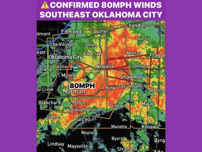
80 MPH Winds Confirmed Southeast of Oklahoma City
Storm reports confirm wind gusts reaching 80 mph in areas just southeast of Oklahoma City, particularly near Moore and surrounding communities. These winds are strong enough to cause structural damage, down trees, and lead to power outages.
Radar imagery shows a powerful line of storms with embedded severe cells, indicating that damaging winds are not isolated but part of a broader, intense system moving across the region.
Tornado Threat Ongoing Across Central Oklahoma
In addition to damaging winds, several tornadoes have been reported with this storm system as it tracks eastward. The presence of multiple warning polygons across central Oklahoma highlights the ongoing risk.
Areas including Norman, Choctaw, and Newalla are experiencing the most intense conditions, with rotation signatures suggesting continued tornado potential as storms evolve.
Shawnee and Eastern Communities Next in Line
The storm system continues to push east, placing Shawnee, Tecumseh, Prague, and nearby areas in immediate danger. Residents in these locations should prepare for rapidly deteriorating conditions, including strong winds, heavy rain, and possible tornado activity.
The forward motion of the storm suggests that impacts will spread quickly, leaving little time for preparation once warnings are issued.
Immediate Safety Concerns as Storms Intensify
With wind speeds already reaching destructive levels and tornadoes embedded within the storm line, conditions remain highly dangerous across central Oklahoma. Travel may become hazardous, and residents are urged to remain indoors and stay updated with warnings.
This is an active and evolving severe weather situation, with threats expected to continue as storms track further east through the night. Stay with NapervilleLocal.com for the latest weather updates and local forecast coverage.

I’ve lived in Naperville long enough to see how quickly our community changes — from new developments downtown to sudden shifts in our Midwest weather. Reporting on Naperville news and daily forecasts gives me the chance to keep neighbors informed about what really matters. My goal is simple: deliver clear, timely updates so you always know what’s happening in our city and what to expect from the skies above.