
Saturday Evening: Strong Storms Build From Louisiana Into South Mississippi With Overnight Severe Risk and Flooding Concerns
SOUTH MISSISSIPPI — Warm, humid, and breezy conditions will dominate Saturday across the region, but attention quickly shifts to the west where thunderstorms are expected to develop and move into South Mississippi later in the evening. Some of these storms could turn strong to severe as they push east overnight into early Sunday.
Saturday Starts Warm but Storms Approach From Louisiana
Most of Saturday will remain dry and warm across South Mississippi, with increasing humidity and breezy conditions setting the stage for storm development. By late evening, thunderstorms are expected to form to the west, particularly over Louisiana, before gradually moving toward Mississippi.
Communities including McComb, Picayune, and areas near the Louisiana border could see storms arrive first, with increasing intensity as they move eastward.
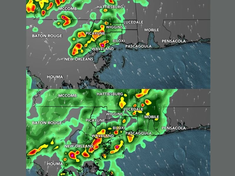
Overnight Brings Strong to Severe Storm Potential
Late Saturday night into early Sunday morning is the primary window for stronger storms. A broken line of thunderstorms is expected to slide across South Mississippi, bringing the potential for heavy rain and isolated severe weather.
Some storms may produce damaging wind gusts exceeding 60 mph, along with the possibility of isolated tornadoes. Hail could also occur, with some stones potentially reaching around 1 inch in diameter. Rainfall totals may reach 1 to 2 inches in some areas, with locally higher amounts possible under heavier storm cells.
Areas Along the Gulf Coast Face Heavier Rain Bands
Locations along and south of I-10, including Waveland, Biloxi, Pascagoula, and nearby coastal communities, could see heavier and more persistent rain bands overnight. These areas may experience brief flooding issues, especially in low-lying or poorly drained locations.
Storms will continue to move east through the overnight hours, gradually weakening as they approach the Alabama border by early Sunday.
Conditions Improve by Easter Sunday Afternoon
Rain and storms are expected to clear out by late Sunday morning or around midday, leading to improving conditions for Easter Sunday afternoon. Cooler air will begin to filter in behind the system, bringing temperatures down into the 60s and 70s.
While early morning activities may still be impacted by lingering rain, the second half of the day should see calmer and more comfortable weather. Stay with NapervilleLocal.com for the latest weather updates and local forecast coverage.

I’ve lived in Naperville long enough to see how quickly our community changes — from new developments downtown to sudden shifts in our Midwest weather. Reporting on Naperville news and daily forecasts gives me the chance to keep neighbors informed about what really matters. My goal is simple: deliver clear, timely updates so you always know what’s happening in our city and what to expect from the skies above.