
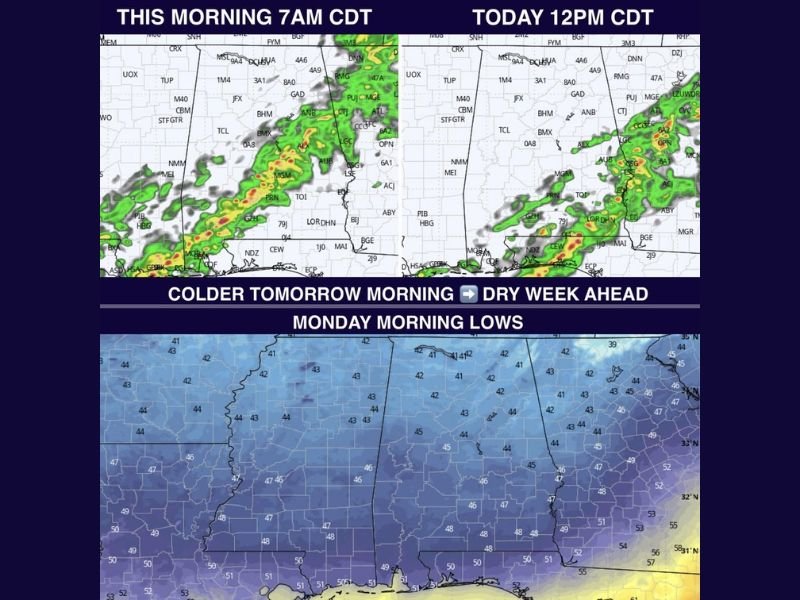
This Morning: Rain Gradually Ends Across Alabama From West to East With Breezy North Winds, Cooler 60s Today, and Chilly 40s Tonight Before Dry Week Ahead
BIRMINGHAM, ALABAMA — Rain is steadily moving out across Alabama this Easter morning, with showers tapering off from west to east as the system exits the region. While much of the state started the day with wet conditions, drier weather will gradually take over through the morning hours, leaving behind lingering cloud cover and noticeably cooler air. Temperatures will remain in the 60s throughout the day, and a steady north wind between 10 to 15 mph will make it feel even cooler at times. This marks a transition toward a quieter weather pattern after several active days.
Morning Rain Moves Out With Clouds Lingering
Showers will continue to push eastward through the morning, with western Alabama already beginning to dry out while central and eastern areas hold onto rain a bit longer. By late morning into midday, most locations should see rain come to an end.
However, clouds will be slow to clear, keeping skies mostly overcast for much of the day and limiting any significant warming.
Cooler Temperatures and Breezy North Winds Today
High temperatures will struggle to climb beyond the 60s across the state, a noticeable drop compared to recent warmth. The added north wind, sustained between 10 and 15 mph, will bring in cooler air and create a slightly brisk feel, especially during the morning hours. Even during the afternoon, the combination of clouds and wind will keep conditions feeling mild rather than warm.
Chilly Night Ahead With Lows Dropping Into the 40s
As skies begin to gradually clear later tonight, temperatures will fall into the 40s across much of Alabama. This will be one of the cooler nights in recent days, though conditions are not expected to be cold enough for frost development. The calmer and clearer conditions overnight will allow temperatures to drop efficiently.
Dry Stretch and Warmer Spring Weather Ahead
This departing system is expected to be the last meaningful rain chance for several days. The upcoming week looks mostly dry, with improving conditions and more sunshine returning.
Clouds may linger into Monday with highs staying in the 60s, but a steady warming trend will follow. Afternoon temperatures will climb into the 70s through midweek, and by next weekend, highs are expected to return to the 80s, signaling a return to typical spring warmth. Stay with NapervilleLocal.com for the latest weather updates and local forecast coverage.

I’ve lived in Naperville long enough to see how quickly our community changes — from new developments downtown to sudden shifts in our Midwest weather. Reporting on Naperville news and daily forecasts gives me the chance to keep neighbors informed about what really matters. My goal is simple: deliver clear, timely updates so you always know what’s happening in our city and what to expect from the skies above.