
This Week Across Alabama: Extended Dry Stretch Continues With Limited Rain Chances, Rising Temperatures Into the 80s, and Drought Concerns Persisting Into Mid-April
ALABAMA — A prolonged stretch of dry weather is settling in across the state, raising growing concerns about ongoing drought conditions as rainfall remains well below normal for this time of year. While the pattern may be favorable for outdoor plans, the lack of meaningful precipitation is becoming increasingly noticeable across much of Alabama.
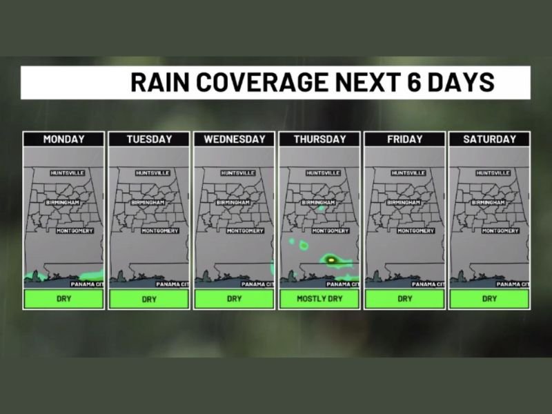
Dry Pattern Dominates Most of the Week
Forecast data shows that dry conditions will remain in place through much of the upcoming week, with very limited opportunities for rainfall. Aside from a slight chance of isolated showers late in the week—primarily across far southern areas—most locations are expected to stay dry day after day.
This means several consecutive days without measurable rainfall, continuing a trend that has already left April totals far below average.
Temperatures Gradually Climb Through the Week
Temperatures will remain comfortable and seasonable to start the week, with highs in the 60s. However, a steady warming trend will take hold quickly, pushing temperatures back into the 70s by Tuesday and Wednesday. By the weekend, much of Alabama is expected to see highs climbing into the 80s, signaling a return to early summer-like warmth.
Chilly Mornings but No Frost Threat
Despite the warming afternoons, mornings will still feel cool, especially early in the week. Overnight lows will dip into the 40s in some areas, but no frost concerns are expected. These cooler mornings paired with warm afternoons will create a noticeable day-to-night temperature swing.
Limited Rain Chances Late Week
A developing weather pattern midweek may introduce a weak boundary between moist and dry air, particularly across southern parts of the state. This could bring a few isolated showers by Thursday, but coverage is expected to be very limited. For the majority of Alabama, the dry pattern will continue uninterrupted.
Why Is It So Dry Right Now?
Rainfall totals for April are running significantly behind normal levels. In Birmingham, only around 0.97 inches of rain has been recorded so far this month, compared to the typical April average of over 5 inches.
This large deficit highlights just how dry conditions have become during what is usually one of the wettest months of the year.
Climate Pattern Playing a Role
The ongoing dry stretch is being influenced by larger climate patterns, particularly a La Niña setup. This pattern often favors drier conditions across parts of the southern United States.
Looking ahead, there are increasing signals that conditions may transition toward a more neutral pattern—and possibly El Niño—by early summer, which could eventually bring wetter conditions back to the region.
No Severe Weather Concerns, But Rain Is Needed
The upside to this pattern is a lack of severe weather threats in the near term. However, the downside is the continued absence of meaningful rainfall, which is critical during the spring season.
For now, the overall outlook suggests that dry weather will dominate not just this week, but potentially into next week as well, with no strong indication of a pattern change anytime soon. Stay with NapervilleLocal.com for continued updates on regional weather patterns and long-range outlooks.

I’ve lived in Naperville long enough to see how quickly our community changes — from new developments downtown to sudden shifts in our Midwest weather. Reporting on Naperville news and daily forecasts gives me the chance to keep neighbors informed about what really matters. My goal is simple: deliver clear, timely updates so you always know what’s happening in our city and what to expect from the skies above.