
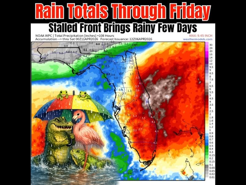
This Week: Florida Faces Multi-Day Rain Event With Stalled Front Bringing 2–5+ Inches Along East Coast and Lighter Totals on Gulf Side Through Friday
FLORIDA — A prolonged stretch of wet weather is setting up across the state this week, as a stalled frontal boundary lingers nearby and continues to funnel moisture into the region. The result will be several days of on-and-off rainfall, with significantly higher totals expected along Florida’s East Coast compared to the Gulf side.
Stalled Front Driving Days of Rain
The primary weather driver behind this pattern is a slow-moving, nearly stationary front, which is expected to remain in place through much of the week. This setup allows moisture to repeatedly move over the same areas, increasing rainfall totals over time rather than delivering everything at once.
Instead of a single heavy rain event, Florida will see multiple rounds of showers and storms, gradually adding up to meaningful weekly totals.
East Coast Expected to See the Heaviest Rain
Forecast projections show a sharp contrast in rainfall across the state:
- East Coast (including central and southeast Florida): Widespread totals of 2 to 5+ inches, with some localized areas potentially exceeding that range
- Central Florida: Moderate totals generally between 1 to 3 inches
- West Coast / Gulf Side: Lower totals, often staying under 1 to 2 inches
This uneven distribution highlights how the position of the front will favor eastern portions of the state for heavier, more persistent rainfall.
Rain Will Come in Waves, Not All at Once
One key detail in this setup is that rainfall will not fall continuously. Instead, periods of rain will be broken up throughout the week, with some days featuring scattered storms and others seeing lighter or more isolated activity.
However, even isolated storms could produce brief heavy downpours, contributing to localized higher totals in certain pockets.
Helpful Rain for Drought Areas
While the wet pattern may cause some temporary disruptions, it also brings beneficial rainfall—especially for areas that have been dealing with dry conditions.
The gradual accumulation of rain over several days will help improve soil moisture levels without necessarily causing widespread flooding issues.
Localized Flooding Still Possible
Despite the overall beneficial nature of this rainfall, there is still a risk for localized flooding, particularly in areas that experience repeated storms or heavier bursts of rain.
Urban locations, low-lying areas, and spots with poor drainage could see temporary water buildup, especially during periods of heavier rainfall.
What to Expect Through Friday
The unsettled pattern is expected to persist through at least Friday, with rain chances continuing each day. By the end of the week, many areas—especially along the East Coast—will have accumulated significant rainfall totals.
Bottom Line
Florida is entering a multi-day rainy pattern, with a stalled front delivering repeated rounds of showers and storms. The heaviest rain will focus on the East Coast, while Gulf-side areas see lighter totals.
While the rain will be spread out over several days, totals will add up—bringing both beneficial moisture and the potential for localized flooding issues. Stay with NapervilleLocal.com for continued updates on this evolving weather pattern and regional impacts.

I’ve lived in Naperville long enough to see how quickly our community changes — from new developments downtown to sudden shifts in our Midwest weather. Reporting on Naperville news and daily forecasts gives me the chance to keep neighbors informed about what really matters. My goal is simple: deliver clear, timely updates so you always know what’s happening in our city and what to expect from the skies above.