
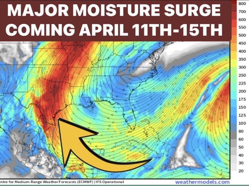
April 11–15: Texas Faces Major Moisture Surge With Severe Storm Risk Starting in West Texas Saturday, Expanding Statewide With Heavy Rain and Tornado Threat Into Midweek
TEXAS — A significant shift in the weather pattern is expected heading into mid-April, as a major moisture surge sets up across the state between April 11th and 15th, bringing an increasing risk of severe storms, heavy rainfall, and potential tornado activity.
Pattern Turning Active Again This Weekend
After a quieter stretch, the atmosphere is gearing up for a much more active phase. A strong influx of Gulf moisture combined with a southwest flow aloft will begin feeding energy into Texas, setting the stage for multiple rounds of storm development.
This setup is particularly favorable for both severe thunderstorms and widespread rainfall, especially as the system strengthens through the weekend.
Saturday: Severe Storms Ignite in West Texas
The first round of activity is expected to develop on Saturday across far West Texas, where storms will fire along the dryline. These storms could quickly become strong to severe, with hazards including:
- Large hail
- Damaging wind gusts
- A potential tornado risk
As the evening progresses, some of this storm energy is expected to push eastward, reaching parts of western Texas overnight.
Sunday: Expanding Storm Threat Across Texas
By Sunday, the upper-level system will move closer, expanding storm coverage and intensity. The severe weather threat will continue across West Texas while North Texas begins to see increasing rainfall and storm activity.
Some storms could still reach marginally severe levels, while heavier rainfall becomes more widespread across northern parts of the state.
Early Next Week: Repeated Rounds of Storms
The active pattern does not end with the weekend. Forecast trends indicate that additional rounds of storms are likely from Monday through Wednesday, with continued moisture streaming in from the Gulf.
This raises the potential for:
- Accumulating rainfall over multiple days
- Periodic severe storm threats
- Increasing chances of localized flooding in areas that see repeated storms
Why This Setup Matters
This type of pattern—featuring sustained moisture inflow and repeated storm development—can lead to compounding impacts over time, even if individual storms are not extreme.
The extended duration of this event, combined with multiple storm rounds, makes it one to watch closely across Texas and surrounding regions.
Bottom Line
Texas is heading into a multi-day severe weather and rainfall event, beginning with strong storms in West Texas on Saturday and expanding across the state into next week.
Residents should stay alert for changing conditions, especially in areas prone to severe storms or heavy rainfall, as this system evolves through mid-April. Stay with NapervilleLocal.com for continued updates on this developing weather pattern and its potential impacts.

I’ve lived in Naperville long enough to see how quickly our community changes — from new developments downtown to sudden shifts in our Midwest weather. Reporting on Naperville news and daily forecasts gives me the chance to keep neighbors informed about what really matters. My goal is simple: deliver clear, timely updates so you always know what’s happening in our city and what to expect from the skies above.