
Numerous Severe Storms With Very Large Hail and Brief Tornado Threat From Supercells Targeting Southwest Texas Including Lubbock, Midland, and San Angelo Tuesday May 26
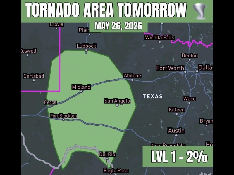
SOUTHWEST TEXAS — Numerous severe storms are expected to develop across southwest Texas on Tuesday, May 26, 2026, with very large hail as the primary hazard mode and a brief tornado or two possible as supercell storms organize early in the event. The tornado risk zone carries a Level 1 designation with a 2 percent tornado probability covering a broad corridor from Lubbock and Midland southward through San Angelo, Fort Stockton, and toward Del Rio and Eagle Pass.
Supercell Mode Expected Early With Very Large Hail as the Primary Severe Hazard
A supercell storm mode is anticipated at least early in the event across southwest Texas on Tuesday, providing the organized storm structure needed to support very large hail production across the risk zone. While the setup is not described as prolific, the ingredients present are more than sufficient for numerous severe storms to develop and impact a wide area through the afternoon and evening.
Very large hail will be the dominant hazard associated with Tuesday’s storm activity, with forecasters identifying it as the primary mode for the event. Residents across Lubbock, Midland, San Angelo, and surrounding communities should protect vehicles and any hail-sensitive property well before storms develop Tuesday afternoon.
Brief Tornado Possible as Supercells Organize Across the Southwest Texas Corridor
Beyond the significant hail threat, the supercell mode expected early in the event carries enough shear and atmospheric support for a brief tornado or two to develop across the risk zone. The 2 percent tornado probability at Level 1 reflects a low but real threat that should not be dismissed across any community within the outlined green risk area.
The tornado risk corridor stretches from near Lubbock southward through Midland, Pecos, and Fort Stockton and toward the Del Rio and Eagle Pass zones along the southern border. Any tornado that does develop is expected to be brief in nature, but even a brief tornado can cause significant damage in its immediate path.
Broad Risk Zone Covers Southwest Texas From Lubbock Through Del Rio Tuesday
The outlined risk zone covers an expansive portion of southwest Texas, stretching from near Clovis and Lubbock in the north southward through Midland, San Angelo, Fort Stockton, and all the way to Del Rio and Eagle Pass along the Rio Grande. This broad geographic footprint means a large population across the region needs to remain weather aware through Tuesday.
Staying connected to local severe weather alerts and having a shelter plan ready before afternoon storm development begins is the most critical preparation step for all residents across the southwest Texas tornado and hail risk zone on Tuesday. Stay with NapervilleLocal.com for the latest weather updates and local forecast coverage.

I’ve lived in Naperville long enough to see how quickly our community changes — from new developments downtown to sudden shifts in our Midwest weather. Reporting on Naperville news and daily forecasts gives me the chance to keep neighbors informed about what really matters. My goal is simple: deliver clear, timely updates so you always know what’s happening in our city and what to expect from the skies above.