
Sunday Outlook April 12: Texas, Oklahoma and Kansas Face Growing Severe Storm Threat With Supercells, Large Hail Risk and Overnight Dryline Activity Expected
UNITED STATES — Forecast models are increasingly pointing toward another active severe weather setup developing by Sunday, April 12, with the focus centered across parts of Texas, Oklahoma, and Kansas. While still several days away, confidence is building that conditions could support organized severe storms, including supercells capable of producing large hail and damaging winds.
Increasing Signals for Weekend Severe Weather
The upcoming pattern shows the atmosphere becoming more unstable again by the weekend, following a brief quieter period. A developing trough moving into the western United States will help trigger storm development across the southern Plains.
This setup is expected to reintroduce strong storm dynamics, especially along and near the dryline—a common boundary where severe storms tend to form in this region.
Sunday: More Volatile Setup Takes Shape
Sunday currently appears to be the more concerning day of the weekend. Forecast guidance suggests a more volatile environment as the system strengthens, increasing the likelihood of:
- Supercell thunderstorm development
- Large hail potential
- Damaging wind gusts
- Isolated tornado risk
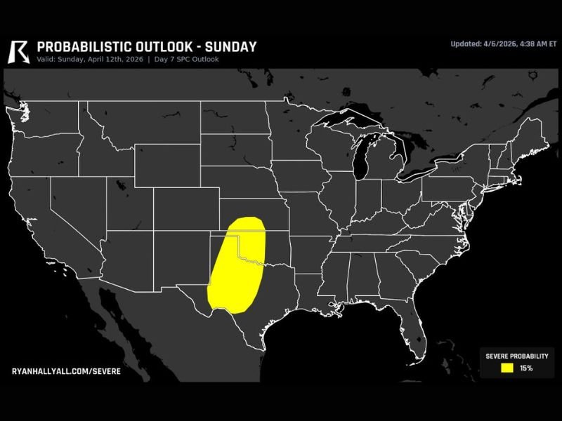
The highlighted risk zone includes central and western Texas extending into western Oklahoma and parts of Kansas, where atmospheric conditions will be most favorable for storm organization.
Dryline to Play a Key Role
Storms are expected to initiate along the dryline during the afternoon and evening hours. As instability increases, these storms could quickly intensify and organize into stronger cells. Additionally, some storms may continue into the overnight period, pushing eastward and expanding their impact area.
Still Early, But Worth Watching Closely
While this setup is still about a week out, early signals are strong enough to warrant attention. Details such as exact storm timing, intensity, and location will continue to be refined as newer data becomes available.
However, the presence of a defined risk area already indicates that this could become a notable severe weather event if trends hold.
What This Means Going Forward
This developing setup is part of a broader active pattern expected across the central United States. With multiple systems expected in the coming days, Sunday could be one of several opportunities for severe weather across the region.
Bottom Line
A potential severe weather outbreak is shaping up for Sunday, April 12, across parts of Texas, Oklahoma, and Kansas, with supercells, large hail, and gusty winds as primary concerns.
Residents in these areas should stay weather-aware over the coming days as the forecast becomes clearer and more detailed. Stay with NapervilleLocal.com for continued updates on this developing severe weather threat.

I’ve lived in Naperville long enough to see how quickly our community changes — from new developments downtown to sudden shifts in our Midwest weather. Reporting on Naperville news and daily forecasts gives me the chance to keep neighbors informed about what really matters. My goal is simple: deliver clear, timely updates so you always know what’s happening in our city and what to expect from the skies above.