
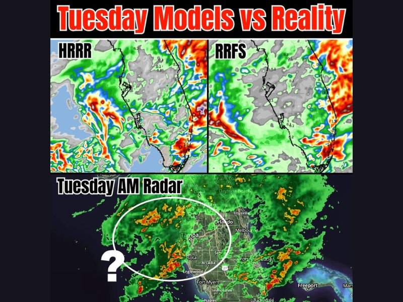
Today: Florida Radar Shows Heavy Rain Near Tampa Despite Models Suggesting Minimal Activity Across West Central Florida
FLORIDA — A noticeable mismatch between weather models and real-time radar is unfolding this morning, as active rain bands and heavier clusters are already developing near Tampa and surrounding parts of west central Florida, despite earlier forecasts suggesting limited activity in the region.
Models Underestimate Rainfall Across West Central Florida
Recent runs of high-resolution models such as HRRR and RRFS indicated very little rainfall for west central Florida today. However, current radar imagery is telling a different story, with organized rain bands and heavier pockets already forming offshore and pushing toward the coast. This discrepancy highlights uncertainty in short-term forecasting, especially in moisture-rich environments like Florida.
Radar Shows Heavy Clusters Near Tampa and Sarasota
Live radar shows multiple clusters of moderate to heavy rain just offshore and beginning to impact areas near Tampa, Sarasota, and surrounding Gulf Coast communities.
Some of these cells contain heavier downpours, which could lead to brief periods of reduced visibility and ponding on roads if they move inland.
Key Question: Will Offshore Rain Make It Inland?
One of the biggest uncertainties now is whether these offshore rain bands will fully move inland or weaken before reaching land.
If the rain maintains its strength and pushes inland, areas across west central Florida could see more widespread rainfall than originally expected. If not, activity may remain more scattered and limited.
Forecast Confidence Remains Uncertain
This situation emphasizes the ongoing challenge of forecasting localized rainfall in Florida, where small shifts in wind patterns and moisture can significantly change outcomes.
Meteorologists will continue monitoring trends throughout the day to determine whether current radar activity becomes the dominant pattern or fades in line with earlier model projections. Stay with NapervilleLocal.com for the latest weather updates and local forecast coverage.

I’ve lived in Naperville long enough to see how quickly our community changes — from new developments downtown to sudden shifts in our Midwest weather. Reporting on Naperville news and daily forecasts gives me the chance to keep neighbors informed about what really matters. My goal is simple: deliver clear, timely updates so you always know what’s happening in our city and what to expect from the skies above.